Year 3 -27 January 2026 -Ella -Nuwara Eliya -Sri Lanka
We were up early and breakfasted at 6.50am and had agreed to meet Chinta down the road at 7.30am and we had arranged for the van to bring down our bags. When we met Chinta we jumped in and headed off to Nuwara Eliya via the Horton Plains where we planned to do a 9km walk through the plains.
This meant retracing our steps to Hepatale and then driving further North into the mountains.
Horton Plains National Park is a National Park in the Central Highlands of Sri Lanka that was designated in 1988. It encompasses an area of 31 km2 (12 sq mi) and borders Thotupalakanda Nature Reserve. It is located at an elevation of 2,100–2,300 m (6,900–7,500 ft) and encompasses montane grassland and cloud forest. It is rich in biodiversity and many species found here are endemic to the region.
The Horton Plains are the headwaters of three major Sri Lankan rivers, the Mahaweli, Kelani, and Walawe rivers. The plains' vegetation is grasslands interspersed with montane forest and includes many endemic woody plants. Large herds of Sri Lankan sambar deer feature as typical mammals and the park is also an Important Bird Area with many species not only endemic to Sri Lanka but restricted to the Horton Plains. Forest dieback is one of the major threats to the park and some studies suggest that it is caused by a natural phenomenon. The sheer precipice of World's End and Baker's Falls are among the attractions of the park.
Horton Plains is located on the southern plateau of the central highlands of Sri Lanka. The peaks of Kirigalpoththa (2,389 m (7,838 ft)) and Thotupola Kanda (2,357 m (7,733 ft)), the second and the third highest of Sri Lanka, are situated to the west and north respectively. The park's elevation ranges from 1,200–2,300 m (3,900–7,500 ft). The rocks in the park belong to the Archean age and to the high series of the Precambrian era and are made up of Khondalites, Charnockites and granitic gneisses. The soil type is of the red-yellow podsolic group and the surface layer is covered with decayed organic matter.
The mean annual rainfall is greater than 2,000 mm (79 in). Frequent cloud cover limits the amount of sunlight that is available to plants. The mean annual temperature is 13 °C (55 °F) but the temperature varies considerably during the course of a day, reaching as high as 27 °C (81 °F) during the daytime, and dipping as low as 5 °C (41 °F) at night. During the southwest monsoon season, the wind speed sometimes reaches gale force. Although some rain falls throughout the year, a dry season occurs from January–March. The ground frost is common in February. Mist can persist for most of the day during the wet season. The park has many pools and waterfalls, and Horton Plains is considered the most important drainage basin in Sri Lanka.
World's End is a sheer cliff with a 870 m (2,850 ft) drop. Baker’s Falls, a waterfall formed by Belihul Oya, a tributary of the Walawe River is named after Sir Samuel Baker. The waterfall is 20 m (66 ft) high, and Slab Rock Falls is another well-known waterfall in the plains. The original name of the area was Maha Eliya Thenna. But in the British period the plains were renamed after Sir Robert Wilmot-Horton, the British governor of Ceylon from 1831 to 1837,
The vegetation of the park is classified into two distinctive groups, 2,000 ha (7.7 mi2) of wet patna and 1,160 ha (4.5 mi2) of subtropical montane evergreen forests. Nearly 750 species of plants belonging to 20 families have been recorded in the park. The forest canopy reaches the height of 20 m (66 ft)
The vertebrate fauna of the region includes 24 species of mammals, 87 species of birds, nine species of reptiles and eight species of amphibians. The Sri Lankan elephant disappeared from the region in the 1940s at the latest. At present, the largest and the most commonly seen mammal is the sambar deer. Some research findings estimate the population of sambar deer to be around 1500 to 2000, possibly more than the carrying capacity of the plains. Other mammal species found in the park include Kelaart's long-clawed shrews, toque macaques, purple-faced langurs, rusty-spotted cat, Sri Lankan leopards, wild boars, stripe-necked mongooses, Sri Lankan spotted chevrotains, Indian muntjacs, and grizzled giant squirrels.
The drive up to Horton Plains was steep and windy. We went through a lot of tall trees many of them eucalyptus which had been planted in the colonial era. We eventually came to the Ohiya park entrance which gave our elevation of 2130 m above sea level. We then we drove for a few miles to a parking area where the park office was. The walks start from there and you are only allowed to walk in certain areas. We passed through some cloud and mist on the way and clearly it looked quite bleak.
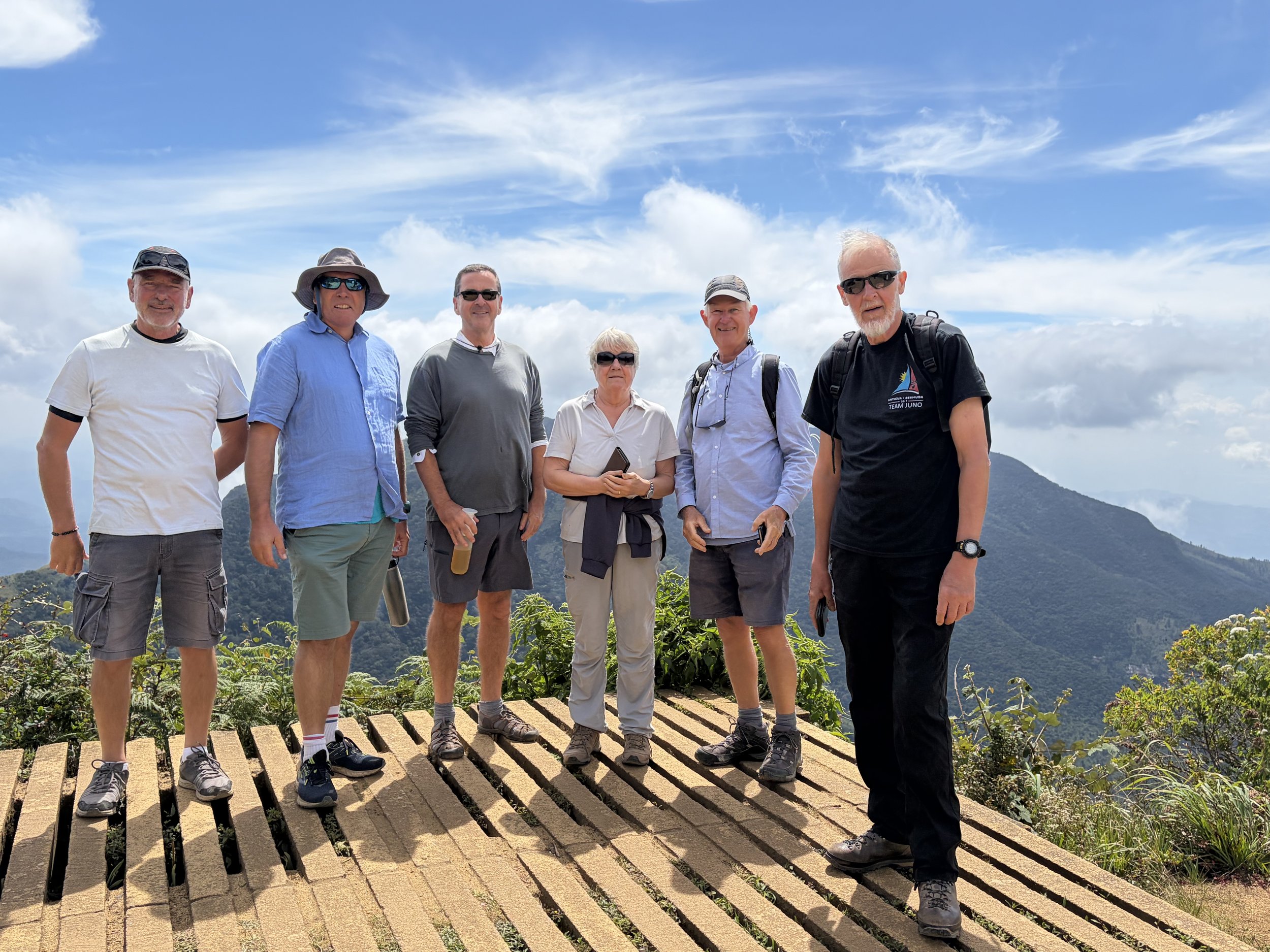
We got out and it was the coldest I have been in for years since I started my trip!! I had not brought a jumper and so I just put on a short sleeved shirt over my tee-shirt and wore a hat (as you lose a third of your body heat through your head). The park was relatively flat and it had some forested areas and lots of short grass bushes (montane grassland) which undulated around us. We set off on our walk which was well marked and came into an old forest which was covered in lichens and moss – it reminded me of an old forest at the top of La Gomera in the Canaries. The forest regulates the temperature and you are protected from the wind. We wandered through and there were a large number of pretty flowers and in the park generally quite a lot of Rhododendron Bushes but only a few were in bloom and it would look stunning when they are in flower. We came out of the forest and came to one look out with a 270 meter sheer drop called Little World’s End and then after some more kilometres the World’s End – with an 870 m drop. We were lucky as when we walked through the old forest the skies cleared and we had blue skies and sun with clouds far away on the horizon. The views from these cliffs were stunning and you could see hills, and villages and lakes far below with terraces where they grew crops and of course tea.
We continued our walk and came to Bakers Falls which was a pretty waterfall and inviting for a swim but this is banned. We walked around a number of rivers and we could see some trout swimming in them. There were some pools where there were loud frogs croaking. However, as soon as I mentioned the word French -they stopped!!.
We continued on through this lovely landscape and I looked out for Leopards, which they have here. However, again I did not see one. There was a sign which warned us of Leopards. It said STOP -If you encounter a Leopard on the trail..
Do not Run, Do not turn your back to the Leopard, Do not get yourself cornered, Do not block the route of the Leopard, Back slowly while maintaining eye contact, Make yourself appear larger (raising arms, expanding jacket etc), Make Noises to assert your presence, Stay as a Group.
So there you are so if you encounter a Leopard on your travels you will know what to do!!.
We continued our walk and came back to the van. We had walked nearly 10km and had walked up 35 floors according to my phone. We had been lucky with the weather and it had not got too cold as we kept moving and the sun had come out. We then drove out of the park through the Pattipola entrance, which has the highest railway station in Sri Lanka. We had seen deer and lots of birds including eagles, some frogs and it had been good to do some exercise and to stretch our legs.
We were driving on to Numara Eliya. Nuwara Eliya is a city in the hill country of the Central Province, Sri Lanka. Its name means "city on the plain (table land)" or "city of light". The city is the administrative capital of Nuwara Eliya District, with a picturesque landscape and temperate climate. It is at an altitude of 1,868 m (6,128 ft) and is considered to be the most important location for tea production in Sri Lanka. The city is overlooked by Pidurutalagala, the tallest mountain in Sri Lanka. Nuwara Eliya is known for its temperate, cool climate – the coolest area in Sri Lanka. The city was founded by Samuel Baker, the explorer of Lake Albert and the upper Nile in 1846. Nuwara Eliya's climate lent itself to becoming the prime sanctuary of the British civil servants and planters in Ceylon. Nuwara Eliya, called Little England, was a hill country retreat where the British colonialists could immerse themselves in their pastimes such as fox hunting, deer hunting, elephant hunting, polo, golf and cricket.
Many of the buildings retain features from the colonial period such as the Queen's Cottage, General's House, Grand Hotel, Hill Club, St Andrew's Hotel and Town Post Office. New hotels are often built and furnished in the colonial style. Visitors to the city can wallow in its nostalgia of bygone days by visiting the landmark buildings. Many private homes maintain their old English-style lawns and gardens. Due to its highland location, Nuwara Eliya has a subtropical highland climate having no pronounced dry season, a monsoon-like cloudy season and with a mean annual temperature of 16 °C (61 °F).
In the winter months, there can be frost at night, but it warms up rapidly during the day because of the high sun angle.
As we drove to Nuwara Eliya we passed through hilly and mountainous areas with lots of farming on terraces and villages perched on the hillsides and of course tea plantations. It was quite busy and everyone was getting on with their lives. It looked quite poor. We eventually came to Nuwara Eliya and we noticed the colonial style buildings. Chinta took us to the Indian restaurant opposite the Grand Hotel where we had a snack. We then walked to the Grand Hotel where people were having afternoon tea on the lawns and drinks. Inside it was a lovely colonial style and it is good that these things are preserved.
We were then taken to our hotel nearby and checked in. I then spent a few hours before supper and after watching England play Sri Lanka at cricket in Colombo which we won. It had been another good day.
The picture of the day is the 6 of us at the World’s End.
Need/Opportunity Year Three
In year three I will be going from Thailand to Sri Lanka, India, Maldives and then on to Mauritius, Reunion, Cape Town, St Helena, Azores and back to the UK.
I am looking for crew from Mauritius/ Reunion Island to Cape Town (mid June to end of July) and from Cape Town to the Azores and then to the UK (mid August onwards). If of any interest do email me.
The blog will continue as we continue the journey. If you have any comments or suggestions about the blog then do email me on hine.nick9@gmail.com