Year 3 -29th September 2026 – Faial -Azores – the most Western Point of Europe
I was on watch at 2.00am and we were sailing toward the waypoint off Pico Island which was still 38nm away.
Paul and John had been struggling to make more than about 5 kts in the conditions as the wind had been so variable. It was quite cool and we all had our wet weather gear on to keep us warm and dry. I have not had to wear it much on this circumnavigation. You could hear the roar of the sea and we still had waves crashing over us from time to time and water on the deck. If you went behind the wheel then you risked being sprayed or splashed or soaked by a growler coming over. Everything was covered in salt and everything tasted of salt. My hair was all salty as well.
I put out a bit more sail and we increased speed and all was going well until the wind increased from about 22 kts to 32kts. I then had to reef back again which was difficult to do on my own and from behind the wheel. I made sure I was clipped on in case a wave came through the cockpit and took me with it.
This increase and decrease in wind and the continued consistent waves made me think and I wondered whether we were still in the front as things were not changing as forecast. However, I had no way of checking as I could not look at the weather. We just had to carry on and we should arrive at Faial in the morning. We had put up with this now for almost 2 days and we just had to continue.
I handed over to a tired Mark and Dave and by this time we only had about 20 nm to go. I went to bed and was so tired I think I did sleep. I was woken by reefing of the sails again and got up. Paul and John were on by now and we were in a position to motor sail now toward the Canal de Faial which is the channel between Faial and Pico. I helped them put the staysail away and we were still on the storm position for the mainsail. We put the engine on and then they set a course motor sailing for the channel.
I went back to bed and was on again at 8.00am. I could see land- Pico Island which looked green and brown. You could see the edges of the caldera – a volcanic cone which disappeared into the cloud. The sky was grey with cloud and looked mean and the sea looked bleak and black and disturbed. It was not as heavy now as we were in the lee of the island.
We motor sailed on and then came to the channel and we could see Faial ahead in the murky conditions looming up in front of us. The channel exposed us more and the waves had white horses on top. The wind was still 22-25 kts and I put the mainsail away. We motored on and Faial began to get clearer. Suddenly I saw a number of dolphins jumping out of the water as if welcoming us to the Azores and the end of our passage. It certainly was heartwarming. We were nearly there.
We motored on and came round the Southern point of the Island. I could now see a large cruise ship in the port behind the large breakwater and a fishing boat coming out.
I got everyone up and called the Port Authority but they did not answer. I called the marina and they did and instructed us to proceed to the reception pontoon. Faial was laid out before us -being very Portuguese really with white buildings and orange/red rooves. It looked quite pretty and was surrounded by green rolling hills with hedges and the odd tree.
We came round the breakwater and then South and there was the long reception wall with the marina full of yachts and fishing boats behind.
At 9.53am we tied up outside the marina office and were greeted by the marina staff. We had arrived. We had travelled 1,412 nm since leaving Cape Verde in 9 days and 47 minutes giving us an average speed of 6.5 kts which was not bad bearing in mind the conditions. This meant we had sailed 5,620nm since leaving Cape Town on the 19 August 2026.
Faial Island is a Portuguese island contained within the Central Group or Grupo Central of the Azores, in the Atlantic Ocean.
The Capelinhos volcano is the westernmost point of the island and can be considered the westernmost point of Europe (from a geophysical perspective) other than the Monchique Islet.
The largest town on the island is Horta with a population of approximately 7,000 inhabitants.
The nearby islands of Pico and São Jorge form an area commonly known as the Triângulo, or Triangle in English.
Faial Island has also been referred to as the Ilha Azul, Blue Island, is a name derived from the writings of Portuguese poet Raul Brandão describing the large and robust number of hydrangeas that bloom during the summer months. The man who had the idea to border the road with these plants should have a statue on the island. In no other place do they prosper better: they need a covering of light, humidity and heat...they are in their place. Their blue is the blue that adorns the Azores on limpid days...this is a blue that is even more blue, the bunches of flowers of a colour more intense and fresh. They are in every direction: rising along the roads and the fields, forming hedges; they serve to divide the plots and to cover the peaceful animals.
Along with other islands in the Azores archipelago, the island of Faial is volcanic, being one of the most volcanically active islands of the archipelago, and is close to the tectonic rift between the European and North American Plates. The island can be considered (from a geophysical perspective) the westernmost point of Europe (the two islands west of Faial, Flores and Corvo are already on the American plate).
The island is shaped as an irregular pentagon that occupies an area of approximately 173 square kilometres (67 mi2), formed along a leaky transform fault extending from the mid-Atlantic Ridge to the Hirondelle faults. This is the same fault that bisects the remainder of the Central Group of islands along a west-northwest to east-southeast orientation. Although formed by complex volcanological events, the current landmass is dominated by the crater of its central stratovolcano with relatively gently sloping flanks, showing little sign of major erosion.
Faial has a humid subtropical climate with some Mediterranean influences, oceanic at higher altitudes. Average temperature is around 17–18 °C (63–64 °F), 20 °C (68 °F) at daytime and 15 °C (59 °F) at nighttime. It has very mild winters for its latitude, in part due to its location in the mid-Atlantic Ocean and influence from the Gulf Stream, averaging 14 °C (57 °F) in its coldest month, February, and frosts never occur other than at high altitude. For comparison, Ocean City, Maryland, at a similar latitude, is 11.4 °C (52.5 °F) colder in its coldest month, averaging only 2.6 °C (36.7 °F). Summers are warm and relatively dry. Temperatures are moderated year-round, never too hot or too cold, daily temperatures are also moderated, with only 5 °C (41 °F) difference between highs and lows.
Average relative humidity remains high at around 80% and insolation is relatively low with around 1800–1900 hours of annual sunshine, similar to locations in coastal northwestern Europe such as Nantes, France, although the sun is stronger in Faial because of its lower latitude. Precipitation is plentiful especially in the winter months, averaging 1,000 mm (39 in) annually. At higher altitudes (e.g. Caldeira Volcano) temperatures are cooler, precipitation and humidity are increasingly higher, and fog is very common. So this is where we are.
I went to the marina office and checked in. Luckily Immigration was there as well. This was the first time some of us had travelled to Europe since the new European system was introduced. We were therefore photographed and had our fingerprints taken. We were then checked in.
We refuelled with some 511 kts and then we had to move back along the wall to berth as there was no marina space available.
We started to sort ourselves out and tidy up. We had some lunch and used up some things and of course a celebratory beer. I apologised to my crew for putting them through that ordeal and thanked them. They were graceful in saying they knew it was coming and did not like the alternative of delay. They were thankful we had come out the other side. You have to respect the sea.
We then all had a rest – and we slept like babies.
Dave and I were up at about 4.00pm and we gave Stormbird a good wash down to get rid of the salt which was everywhere. Once done we showered and all went out for supper at the Clube Naval Da Horta where we enjoyed some dinning out food and of course the local Sagres beer and some red wine from Pico. It was a nice feeling that we had arrived and were safe. Quite an achievement.
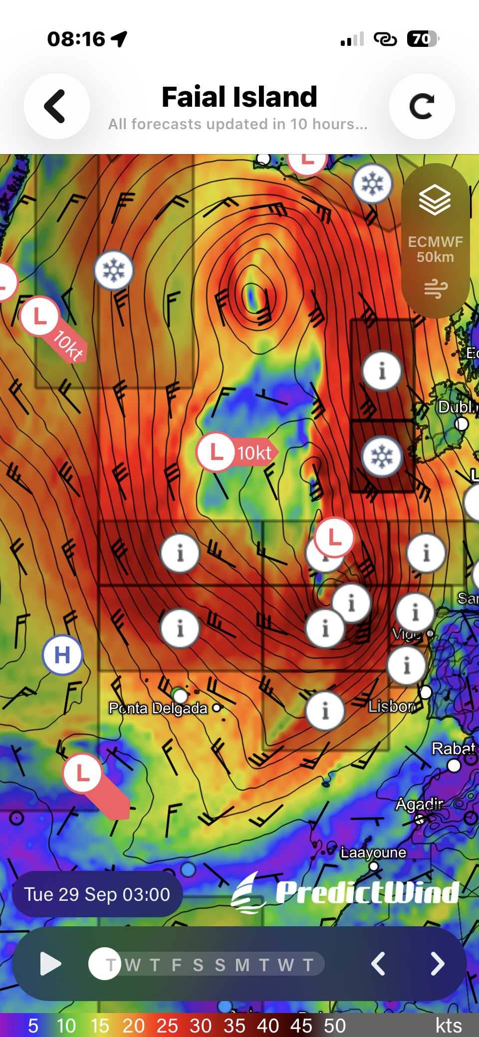
Once I had connectivity I checked the weather and I was right the system had not yet moved off and had joined another and was then heading on to Europe. I followed its projection and it is going to go East of Ireland and will at its peak have waves of 10m. I would not want to be out in that?
Paul, John and I went to a bar after supper and had one for the road as it were. We all went to be tired. However, at least the bed was flat and not moving!!
The picture of the day is the picture of the system when I looked it up. We are the white dot at the bottom and the system had passed us going North.
Need/Opportunity Year Three
I am now at the Azores and hope to head back to the UK on about 9 October 2026. At present I am full for the final passage back to the UK with some old veterans returning David Mark, Keith Watson (Watty) and of course Keith Winstanley -the Commodore.
The blog will continue as we continue the journey. If you have any comments or suggestions about the blog then do email me on hine.nick9@gmail.com