Year 3 -13 June 2026 -Mauritius – La Reunion
We woke early as we had to be at the customs wall by 8.30am. Hisham went off early to buy some bread but one shop was closed and the other would not take cards. We therefore had our usual fruit etc. breakfast.
We had talked through what we were going to do and so John and I prepared slips for the bow and stern lines. Carolyn and Joyce went to walk round to the wall to take our lines when we arrived. We took off the electric lead and prepared to leave. We then put on the instruments and the engine on and slipped the lines and eased out of the basin.
We slowly motored forward and headed toward the customs wall. On our right was a yellow buoy where we were told there was a rock. We were well off that point and some 70m off the quay when we suddenly came to a stop. We had only been doing 2 kts and we seemed to have hit something. I tried to get off what it was but could not. What an earth was it I thought? There was nothing on the chart and no buoy or anything to mark an obstruction.
I got on the radio to Port Control and asked for some help. There was a work boat in the basin we had been in and they had heard my message and they came out to help us. We attached a line to the centre cleat on the port side and they pulled us sideways and we were soon clear. One of the guys said there is all sorts of stuff in the water here and it is appalling they have not done anything about it.
We went straight to the centre of the channel and then headed to the customs wall where Carolyn and Joyce took our lines. The agent’s rep was there and took our passports and we had to wait for Immigration to stamp our passports.
I went to check the bilges and all seemed fine and there was no ingress of water. We had not hit what we had hit hard and Hallberg Rassy’s are designed to withstand the odd rock hit. I was very annoyed as you can imagine. Luckily we only had to wait about 35 minutes and we had our passports stamped and clearance documents. We got off the wall and headed off up the channel. I checked with Port Control and got permission to leave the port.
The fenders and lines were put away and we headed out of the port and turned Southwest toward Reunion which was about 140nm away. There was little wind and what there was, was on the nose so we motored through a field of anchored tankers and cargo ships and headed for a waypoint I had set off the Northeast coast of Reunion. Hisham made some pancakes which were delicious and we all enjoyed them and chatted away excited to be on our way to Reunion.
It was a lovely day and the sea state was pretty calm and just a slight rise and fall of a long ocean swell -perhaps 1-1.5m in height.
At about 1.30pm the wind came round to East Southeast and rose to about 10 kts so up went the main and genoa. The wind increased further to 12-14 kts and we were soon making 8-8.5kts which is a good speed. The problem was that it would get us to our waypoint at 2-3.00am and it was only 11nm to the port from there. I therefore decided to bring in the genoa and use the staysail. I took in the Mauritian flag and put up the French flag and the yellow duster (Q flag).
We continued like this and then I put a reef in the main as we were still going too fast. It is sometimes difficult to slow Stormbird down when she is going.
John put out the fishing rod and we hoped to catch a fish. Some had lunch and others did not want any.
The afternoon wore on. John and I were on watch until 12.00noon and we did the daily checks. Keith and Hisham took over at 12 and did the fruit turning etc. I made some bread and Carolyn and Joyce took over at 4.00pm. We saw quite a few sea birds and the odd flying fish. I did another weather check and the updated forecast suggested the wind would die about 2-3.00am and so I decided to return to the genoa so we could make good miles before it dies. We will just have to judge as best we can our speed and distance to go. Visibility was very good and we could see cargo ships 20nm away which is unusual. There were a few cargo ships around and the odd fishing boat but otherwise no traffic.
John and I made supper. We had pasta pesto – but the pesto we had put in the freezer and which we (Cari & Miranda) made from the produce given to us from the hyponics farm in the Maldives. We also had a good salad. This all went down well and we enjoyed it sitting in the dark in the cockpit.
John and I were on at 8.00pm and when Carolyn handed over she saw what seemed to be a large fishing fleet ahead of us where there was a large white glow. We were some 55 nm from Reunion so it could not be the island. John and I kept a good eye out. The stars were out and there was no light pollution and we could see so many stars and the milky way. As time went on we realised that thew glow was the lights of the island and we were seeing more than 50 nm away. As we neared it became more clearer and we could see aircraft taking off. So what about Reunion.
Réunion (known as Île Bourbon before 1848) is an island in the Indian Ocean that is an overseas department and region of France within the African region. Part of the Mascarene Islands, it is located approximately 679 kilometres (367 nautical miles) east of the island of Madagascar and 175 kilometres (94 nmi) southwest of the island of Mauritius. As of January 2026, it had a population of 910,985. Its capital and largest city is Saint-Denis.
Before the arrival of French colonial subjects and immigrants in the 17th century, Réunion was an uninhabited island. Its tropical climate led to the development of a plantation economy focused primarily on sugar; slaves from East Africa were imported as fieldworkers, followed by Malays, Vietnamese, Chinese, and Indians as indentured labourers. Today, the greatest proportion of the population is of mixed descent, while the predominant language is Réunion Creole, though French remains the sole official language.
Since 1946, Réunion has been governed as a French region and thus has a similar status to its counterparts in Metropolitan France. Consequently, it is one of the outermost regions of the European Union and part of the eurozone; it is, along with the French overseas department of Mayotte, one of the two eurozone areas in the Southern Hemisphere and in Africa. Owing to its strategic location, France maintains a large military presence on the island. The French took possession of the island in the 17th century, naming it Isle Bourbon after the House of Bourbon which then ruled France. To break with this name, which was too attached to the Ancien Régime, the National Convention decided on 23 March 1793 to rename the territory La Réunion ("réunion", in French, usually means "meeting" or "assembly" rather than "reunion"). This name was presumably chosen in homage to the meeting of the fédérés of Marseilles and the Paris National Guards that preceded the insurrection of 10 August 1792. No document establishes this, and the word "meeting" could have been purely symbolic.
The island changed its name again in the 19th century: in 1806, under the First Empire, General Charles Decaen named it Isle Bonaparte (after Napoleon), though, in 1810, it became Isle Bourbon again. It was eventually renamed La Réunion after the fall of the July monarchy by a decree of the Provisional Government on 7 March 1848.
In accordance with the original spelling and the classical spelling and typographical rules, "la Réunion" was written with a lower case in the article, but during the end of the 20th century the spelling "La Réunion" with a capital letter was developed in many writings to emphasize the integration of the article in the name.
The island is 63 km (39 mi) long; 45 km (28 mi) wide; and covers 2,512 km2 (970 mi2). It is above a hotspot in the Earth's crust. The Piton de la Fournaise, a shield volcano on the eastern end of Réunion, rises more than 2,631 m (8,632 ft) above sea level and is sometimes called a sister to Hawaiian volcanoes because of the similarity of climate and volcanic nature. It has erupted more than 100 times since 1640, and is under constant monitoring, most recently erupting on 2 July 2023. During another eruption in April 2007, the lava flow was estimated at 3,000,000 m3 (3,900,000 yd3) per day. The hotspot that fuels Piton de la Fournaise also created the islands of Mauritius and Rodrigues.
The Piton des Neiges volcano, the highest point on the island at 3,070 m (10,070 ft) above sea level, is northwest of the Piton de la Fournaise. Collapsed calderas and canyons are southwest of the mountain. While the Piton de la Fournaise is one of Earth's most active volcanoes, the Piton des Neiges is dormant. Its name is French for "peak of snows", but snowfall on the summit of the mountain is rare. The slopes of both volcanoes are heavily forested. Cultivated land and cities like the capital city of Saint-Denis are concentrated on the surrounding coastal lowlands. Offshore, part of the west coast is characterised by a coral reef system. Réunion also has three calderas: the Cirque de Salazie, the Cirque de Cilaos and the Cirque de Mafate. The last is accessible only on foot or by helicopter.
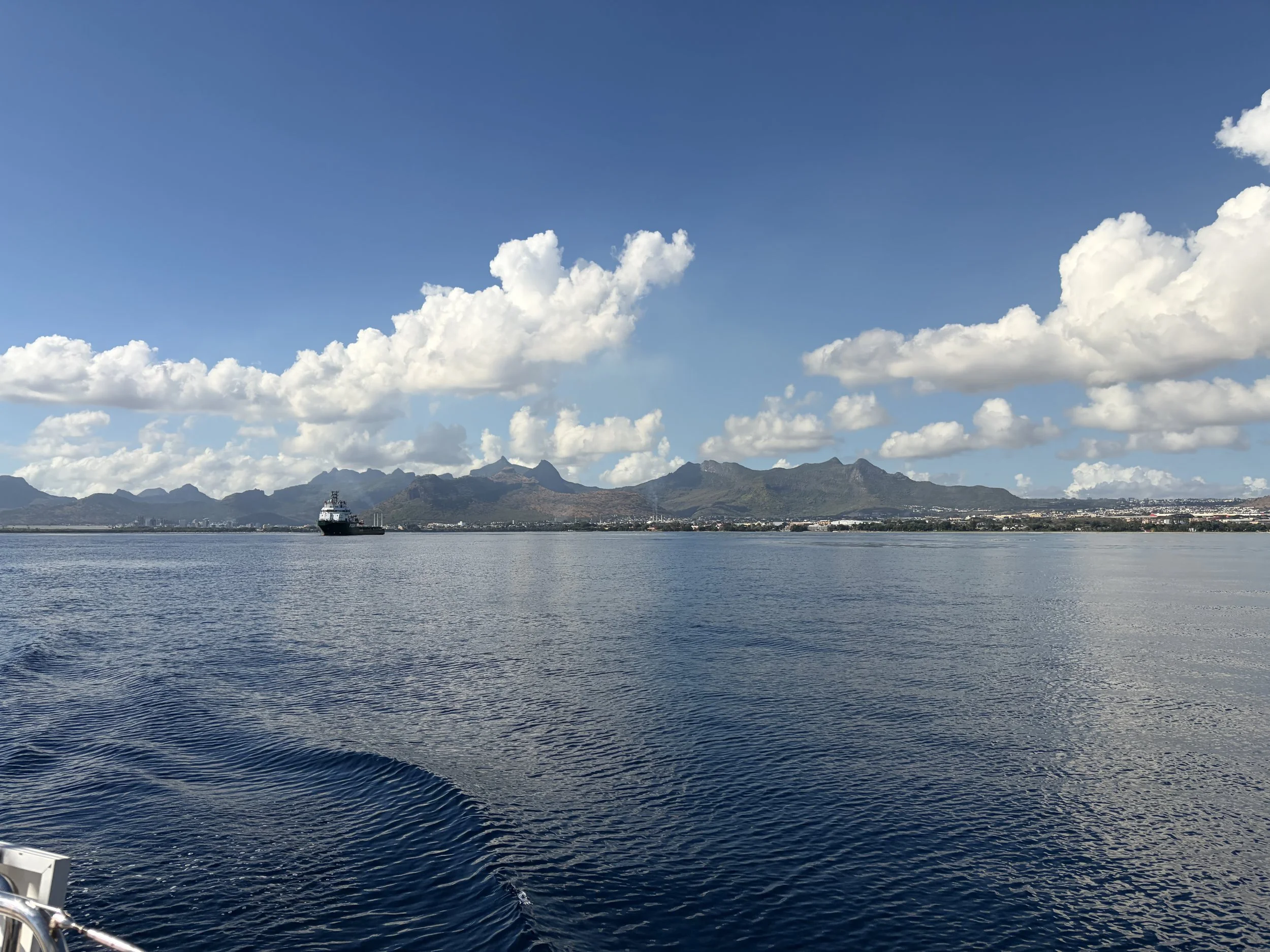
The picture of the day is the last view of Mauritius.
Need/Opportunity Year Three
I am now in Mauritius and will be going to Reunion, Cape Town, St Helena, Azores and back to the UK.
I have now found additional crew for Mauritius to Durban. There may be space from Durban to Cape Town from about the beginning of July and we should arrive in Cape Town on about 25-30 July 2026. If at all interested contact me on my email below or WhatsApp +44 7931360372.
The blog will continue as we continue the journey. If you have any comments or suggestions about the blog then do email me on hine.nick9@gmail.com