Year 2- 7 September 2025 – Gili Banta Island to Bima on Sumbawa
We had a 6.30am start and it was still quite windy and we were still moving round a bit. I had got up in the middle of the night to check all was well and the anchor was holding well despite the current and wind. We had some tea and then prepared to raise the anchor and I hoped that we would not have problems lifting it and that the chain was not caught around some coral. We started to raise it and it was getting tight for a bit and then luckily it came free and we were able to raise it fully. Phew!
We motored of the bay passing a large motor yacht moored some way out. We came out the bay and then started to head West toward Sumbawa the next main Island. We put up the genoa and were soon sailing along quite nicely but you could see, as referred in the pilot books, that this bit of water is quite disturbed and there was quite a swell and white horses. To our right was Sangeang an Island off Sambawa with two volcanic peaks.
Sangeang is an island and an active volcano named Gunung Sangeang (Sangeang Api) located northeast of the island of Sumbawa in Indonesia, not in the Sunda Strait between Java and Sumatra. It is part of the Lesser Sunda Islands and is known for its volcanic activity, with two main peaks, Doro Api and Doro Mantoi Gunung Sangeang (or Sangeang Api) is a very active island volcano, just off the north coast of Sumbawa. The island is 13km wide and there are two main peaks with about 2 kilometres between them, which are named on old topographic maps as Doro Api (1,949m) in the north and Doro Mantoi (1,795m) in the south. The Sangeang Api erupted in 1988 and the island's inhabitants were evacuated. Between its first recorded eruption in 1512 and 1989, it erupted 17 times. It erupted again during December 2012 and May 2014.
There are two peaks which we had seen the day before but they were now covered in cloud. We were planning to go a little along Sumbawa to an anchorage. The nearest was Ware but it can suffer from roll and the next is the city of Bima, some 10nm further and some 9nm down an inlet. We sailed on toward the gap between Sumbawa and Sangeang which is only about 2nm wide. It is a shipping route and we had a tanker in front of us and another coming up behind us. We maintained our course and sailed along well toward the gap being rolled a bit by the swell but making good progress. I made water and filled the starboard tank. I called up the tanker behind us -Gaya Ambon and they were happy for us to maintain our course and they should pass in front of us which they did.
We continued on our course and then behind us came a passenger ferry and we stayed to the port and on the radio suggested he passed us to Starboard. As they were passing they called us up and thanked us which was nice. As we had passed through the gap we could not just continue on course due to the wind angle so we gybed for a while and went out and then gybed back again. We were fishing again so let’s hope we will catch something.
We sailed on and not forecast the wind increased and we began to see 24, 25 and then the odd 29 kts (a Force 7) so we got the staysail out and were still making 7 plus kts despite the swell. We continued past Ware which looked very exposed and continued to the entrance to Bima. By this time the wind seemed to swing from Southeast to North and then Southwest on the nose. This meant that we had to motor into the swell and the wind. I took in the fishing rod and alas we had not caught anything.
Sumbawa, is an Indonesian island, located in the middle of the Lesser Sunda Islands chain, with Lombok to the west, Flores to the east, and Sumba further to the southeast. Along with Lombok, it forms the province of West Nusa Tenggara, but there have been plans (currently held in abeyance) by the Indonesian government to split the island off into a separate province. Traditionally, the island is known as the source of sappanwood, as well as honey and sandalwood. Its savanna-like climate and vast grasslands are used to breed horses and cattle, as well as to hunt deer.
Sumbawa has an area of 15,448 square kilometres or 5,965 square miles (three times the size of Lombok) with a population (at the 2020 Census) of 1,561,461. It marks the boundary between the islands to the west, which were influenced by religion and culture spreading from India, and the region to the east which was less influenced. In particular, this applies to both Hinduism and Islam. While the name "Sumbawa" is used by outsiders for the whole island, locally the term is only applied to the western half (Sumbawa and West Sumbawa Regencies), while the eastern half is referred to by inhabitants as "Bima" (meaning the city as well as Bima and Dompu Regencies), as the two parts of the island are divided by geography, culture and language.
Bima city is a coastal city on the east of the island of Sumbawa in Indonesia's province of West Nusa Tenggara. It is the largest city on the island of Sumbawa, with a population as at mid-2024 was 165,113. The people of Bima and the entire eastern side of Sumbawa speak the Bima language. From 1620 to 1958 it was the capital of the Bima Sultanate. In modern times, Bima city is the largest regional and economic hub of Eastern Sumbawa with transmigrants from other parts of Indonesia, especially Java, Bali, and Lombok. It has a central downtown commercial zone. It is home to the Sultan Salahuddin mosque and the Sultan Salahuddin Museum (former Bima Sultanate palace).
We motored on and gradually entered the inlet which led over 9 nm to Bima. We could see various villages and ports either side and lots of fishing boats at anchor or moored including many squid boats and I assume they all go out at night. There were so many could they really all catch fish/squid – would there be any left? We meandered down the inlet with its brown sides with some bushes here and there. There were some small, long boats phut phutting around. We motored on in choppy water and eventually came to the port with some large cargo ships anchored. We could see the odd mosque and a town spread out on the left. We did not fancy the anchorage near the port so went on past the town and into a shallower bay and anchored in about 7m of water. This was reasonably sheltered and there was little swell. We could see lots of buildings along the shoreline and music being played. We could see and hear the road and the rumble of traffic from time to time.
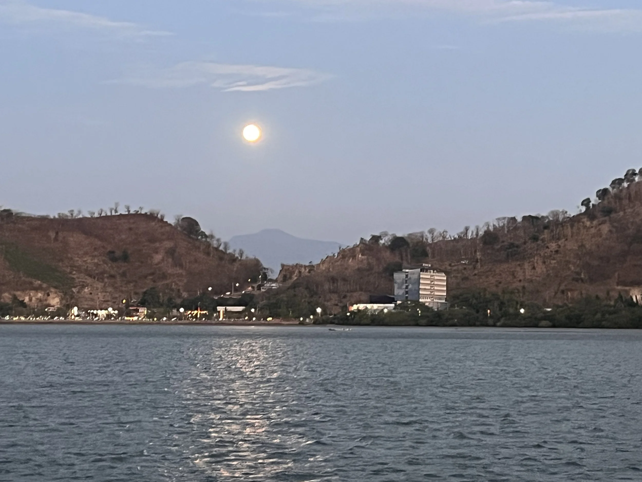
We had some tea and settled and watched what was going on. I made my spiced red cabbage dish and we decided we would have this with the last of the bolognaise. We had a beer on the aft deck and saw various men in the water fishing with the water up to their armpits. We saw a man on a horse ride down the shore and then in the distance several horses in the water with their riders. We saw a longboat come into the bay and gradually with a pole he pushed the longboat around the bay dragging a net. There was a call to prayer going on as well. The sun went down behind the clouds and the moon came up opposite which was over the active volcano on Sangeang. The shore is it up with streetlights, traffic light and buildings. We know we are in a city which is quite a contrast from the last few days.
I heated up the food and we eat it in the breeze which was pleasant and we finished our plates.
We think we will move on tomorrow as we do not fancy going ashore here.
The picture of the day is a picture of the moon over the city and volcano on Sangeang.
Need/Opportunity Year Three
In year three I will be going from Thailand to Sri Lanka, India, Maldives and then on to Chagos, Mauritius, Reunion, Cape Town, St Helena, Azores and back to the UK. I am looking for crew from Mauritius/ Reunion Island to Cape Town and from Cape Town to the UK. If of any interest do email me.
The blog will continue as we continue the journey. If you have any comments or suggestions about the blog then do email me on hine.nick9@gmail.com