Year 2- 19 September 2025 –Badas Bay to Gili Air-Lombok
I was woken early by the Adhan and after trying to sleep gave up and got up. It was a pleasant day and we were moving on. We had to get the dinghy up and prepare to go which we did and we were the second boat to leave the anchorage as we had seen Sandy Key leave before us.
Once we were under way Ruth made banana pancakes which was nice and we initially motored for a way. The wind increased a bit and so we started to sail and I began to make water. We need to be in Bali by mid-morning on 24th September as I am flying home that evening for my brother’s wedding. I need to leave the boat with two full water tanks. Working backwards we are in Marina del Rey (Lombok) or the nights of the 21/22 and so we have two nights before then. If we do not do a long day today then we will have to do so tomorrow so my thought was to do the distance today and then we can enjoy tomorrow more. In terms of water making you want good clear water so today made sense to make it as we were some way out in comparison to being close inshore which is what we will be tomorrow. I therefore over about 3 hours made water which slowed us down as we were only making about 4kts under sail but at least we filled the tanks.
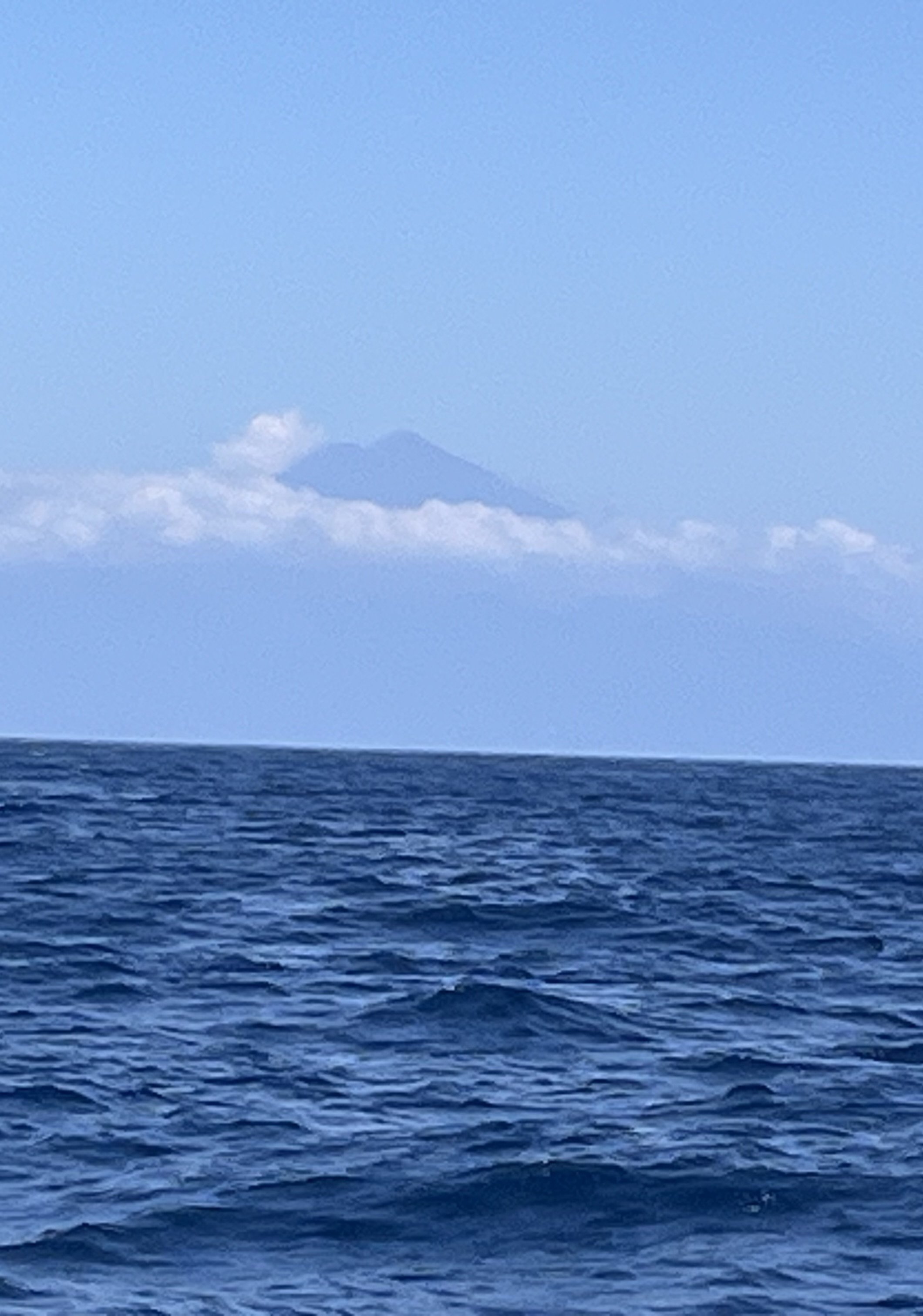
Once this was done we had to motor and the wind did not increase all day. We motored on past the end of Sumbawa and began to see Mount Rinjani, towering over the clouds – see today’s picture. We had two visits from Dolphins on the way which was nice. Otherwise there was the odd ship passing further out.
Lombok is an island in the West Nusa Tenggara province of Indonesia. It forms part of the chain of the Lesser Sunda Islands, with the Lombok Strait separating it from Bali to the west and the Alas Strait between it and Sumbawa to the east. It is roughly circular, with a "tail" (Sekotong Peninsula) to the southwest, about 70 kilometres (43 miles) across and a total area of about 4,566.54 square kilometres (1,763.15 square miles) including smaller offshore islands. The provincial capital and largest city on the island is Mataram.
Lombok is somewhat similar in size and density, and shares some cultural heritage with the neighbouring island of Bali to the west. However, it is administratively part of West Nusa Tenggara, along with the larger but less densely populated island of Sumbawa to the east. Lombok is surrounded by a number of smaller islands locally called Gili. The island was home to some 4 million people in the 2024 census. Lomboq is Sasak for straight, honest.
The island's topography is dominated by the centrally located stratovolcano Mount Rinjani, the second-highest volcano in Indonesia, which rises to 3,726 metres (12,224 ft), making Lombok the 8th-highest island. The most recent eruption of Rinjani occurred in September 2016 at Gunung Barujari. In a 2010 eruption, ash was reported as rising 2 kilometres (1.2 miles) into the atmosphere from the Barujari cone in Rinjani's caldera lake of Segara Anak. Lava flowed into the caldera lake, raising its temperature, while ash fall damaged crops on the slopes of Rinjani. The volcano and its crater lake, Segara Anak (child of the sea), are protected by the Gunung Rinjani National Park established in 1997. The highlands of Lombok are forest-clad and mostly undeveloped. The lowlands are highly cultivated. Rice, soybeans, coffee, tobacco, cotton, cinnamon, cacao, cloves, cassava, corn, coconuts, copra, bananas and vanilla are the major crops grown in the fertile soils of the island. The southern part of the island is fertile but drier, especially toward the southern coastline.
We had lunch and continued to motor having an hour on and an hour off and we had a little tide against us. I looked at our options for arriving in the dark and Gili Air has a number of reefs around it. I therefore looked at other options and contacted Anders from Yaghan (another HR 62) which I think was anchored there. I spoke to him and he was there and we discussed whether I could get in but we concluded it would be safer to go nearby and we can move round in the morning.
We motored on and we began to see the sun go down and we prepared for the night period. As it got darker we put the instruments into night mode and put our navigations lights on. We had put in a number of waypoints and so we started to follow them. We were concerned about Fad’s as they are not lit at night but luckily we did not come across any. However, we did see a lot of fishing boats and strobe lights which we think were big fishing nets. We motored on and there were quite a lot of lights on the shore. We had to navigate round various reefs and I put my forward-looking sonar on as well. I was watching depth, looking ahead and the instruments together and we picked our way through the reefs.
Ruth heated up the curry with broccoli which was good and warning. We continued on and intended to anchor off the East side of Gili Air. Once we got there we could see all sorts of local boats there in the place of what they suggested was an anchorage. We tried twice to anchor but it was too rolly and there was little space. I therefore decided to move from there to a bay on Lombok which was in the pilot book. It was now getting late and so we motored over. The pilot book is quite old now and we eased into the bay. There were now all sorts of moorings and boats anchored and there seemed to be little space. However, we eased in and found a spot in the middle and between a whole load of boats on mooring buoys. We anchored in about 20 m of water. It was very sheltered and there was little wind which was good. We only put out about 60m of chain to stop us swinging too much. At that level we should be ok provided the wind does not increase. We had travelled some 88 nm and we had done the miles which should make tomorrow an easy day.
The picture of the day is Mount Rinjani appearing out of the clouds from some distance.
Need/Opportunity Year Three
In year three I will be going from Thailand to Sri Lanka, India, Maldives and then on to Chagos, Mauritius, Reunion, Cape Town, St Helena, Azores and back to the UK. I am looking for crew from Mauritius/ Reunion Island to Cape Town and from Cape Town to the UK. If of any interest do email me.
The blog will continue as we continue the journey. If you have any comments or suggestions about the blog then do email me on hine.nick9@gmail.com