Year 3 -18 February 2026 – Periya National Park -Kumily -Munnar India
We had a reasonable breakfast and the agent had organised the extension of our trip to take us over to the Munnar area which had been recommended before we return to Kochi.
We are still in the Kerala state -which literally means land and coconut. It has sparkling palm -shaded backwaters, gold fridged beaches and the wildlife prowled mountains of the Western Ghats which is the range of hills parallelling the Western coast for some 1500km.
Kerala is a state of India on the Malabar Coast. It was formed on 1 November 1956 under the States Reorganisation Act, which unified the country's Malayalam-speaking regions into a single state. Covering 38,863 km2 (15,005 sq mi), it is bordered by Karnataka to the north and northeast, Tamil Nadu to the east and south, and the Laccadive Sea to the west. With 33 million inhabitants according to the 2011 census, Kerala is the 13th-most populous state in India. It is divided into 14 districts, with Thiruvananthapuram as the capital. Malayalam is the most widely spoken language and, along with English, serves as an official language of the state.
Kerala has been a prominent exporter of spices since 3000 BCE. The Chera dynasty, the first major kingdom in the region, rose to prominence through maritime commerce but often faced invasions from the neighbouring Chola and Pandya dynasties. In the 15th century, the spice trade attracted Portuguese traders to Kerala, initiating European colonisation in India.
After Indian independence in 1947, Travancore and Cochin acceded to the newly formed republic and were merged in 1949 to form the state of Travancore-Cochin. In 1956, the modern state of Kerala was formed by merging the Malabar district, Travancore-Cochin (excluding four southern taluks), and the Kasargod taluk of South Kanara.
Kerala has the highest Human Development Index, at 0.784 in 2018; the highest literacy rate, 96.2% in 2018; the highest life expectancy, at 77.3 years; and the highest sex ratio, with 1,084 women per 1,000 men and the lowest positive population growth rate in India (3.44%). It is the least impoverished and the second-most urbanised state in the country. The state has witnessed significant emigration, particularly to the Arab states of the Persian Gulf during the Gulf Boom of the 1970s and early 1980s, and its economy relies heavily on remittances from a large Malayali expatriate population. Hinduism is practised by more than 54% of the population, followed by Islam and Christianity. The culture is a synthesis of Aryan and Dravidian traditions, shaped over millennia by influences from across India and abroad.
The production of black pepper and natural rubber contributes significantly to the national output. In the agricultural sector, coconut, tea, coffee, cashew, and spices are important crops. The state has a coastline of 595 kilometres (370 mi), and 1.1 million people depend on the fishing industry, which accounts for around 3% of the state's income. The economy is largely service sector oriented, while the primary sector contributes a comparatively smaller share. Kerala has the highest media exposure in India, with newspapers published in nine languages, primarily Malayalam and English.
Named as one of the ten paradises of the world by National Geographic Traveler, Kerala is one of the prominent tourist destinations of India, with coconut-lined sandy beaches, backwaters, hill stations, Ayurvedic tourism and tropical greenery as its major attractions. The state has been repeatedly recognised in international travel rankings for its natural landscape and cultural heritage.
The state is wedged between the Laccadive Sea and the Western Ghats. Kerala experiences humid tropical rainforest climate with some cyclones. The width of the state varies between 11 and 121 kilometres (7 and 75 mi). Geographically, Kerala can be divided into three climatically distinct regions: the eastern highlands; rugged and cool mountainous terrain, the central mid-lands; rolling hills, and the western lowlands; coastal plains.
The Western Ghats rise on average to 1,500 metres (4,900 feet) above sea level, while the highest peaks reach around 2,500 metres (8,200 feet). Anamudi in the Idukki district is the highest peak in south India, is at an elevation of 2,695 m (8,842 ft). The Western Ghats mountain chain is recognised as one of the world's eight "hottest hotspots" of biological diversity and is listed among UNESCO World Heritage Sites. The chain's forests are considered to be older than the Himalaya mountains. The Athirappilly Falls, which is situated on the background of Western Ghat mountain ranges, is also known as The Niagara of India.
Kerala's western coastal belt is relatively flat compared to the eastern region, and is criss-crossed by a network of interconnected brackish canals, lakes, estuaries, and rivers known as the Kerala Backwaters. Kuttanad, also known as The Rice Bowl of Kerala, has the lowest altitude in India, and is also one of the few places in world where cultivation takes place below sea level. The country's longest lake Vembanad, dominates the backwaters; it lies between Alappuzha and Kochi and is about 200 km2 (77 sq mi) in area. Around eight percent of India's waterways are found in Kerala. Kerala has 44 rivers including the Periyar; 244 kilometres (152 mi), and the average length of the rivers is 64 kilometres (40 mi). Many of the rivers are small and entirely fed by monsoon rain. As Kerala's rivers are small and lacking in delta, they are more prone to environmental effects. The rivers face problems such as sand mining and pollution. The state experiences several natural hazards like landslides, floods and droughts. The state was also affected by the 2004 Indian Ocean tsunami, and in 2018 received the worst flooding in nearly a century. In 2024, Kerala experienced its worst landslides in history.
Kerala produces 97% of the national output of black pepper and accounts for 85% of the natural rubber in the country. Coconut, tea, coffee, cashew, and spices—including cardamom, vanilla, cinnamon, and nutmeg are the main agricultural products. Around 80% of India's export quality cashew kernels are prepared in Kollam. The key cash crop is coconut and Kerala ranks first in the area of coconut cultivation in India. Around 90% of the total Cardamom produced in India is from Kerala. India is the second-largest producer of Cardamom in world. About 20% of the total Coffee produced in India are from Kerala. The key agricultural staple is rice, with varieties grown in extensive paddy fields. Home gardens made up a significant portion of the agricultural sector.
We have been through quite a lot of Kerala in the last few days and it is a beautiful and so lush.
Munnar was about 100km slightly Northwest. It is strategically located 1524m high at the meeting point of 3 rivers about 135km from Kochi. It is at the heart of the largest tea producing region in South India. Kerala’s Western Ghats here can be shrouded in mist. The area was developed as a tea producing region in the 1880’s onwards. It is now apparently a bustling town where tea and cardamon growing rub shoulders with tourism.
We set off at 9.00am and had soon left Kumily and the Periya behind. We were going across country and the road essentially went through lush jungle which as stunning. There were lots of trees in bloom and splashes of colour in the flowers by the side of the road regularly – reds, yellows, whites, pinks, oranges etc it was stunning. We were also passing through the Western Ghats and the road went up and down.
We stopped at Ramakkalmedu.
Ramakkalmedu is a hill station and a hamlet in Idukki district in the Indian state of Kerala. The place is noted for its panoramic beauty and numerous windmills. Ramakkalmedu stands tall in the western ghats at a height of 3,500 ft (1,100 m) above sea level. Ramakkalmedu is a historic site with a monument to Kuravan and Kurathi, a large statue that depicts the Sangam Period and Sangam landscape of Kerala and Tamil Nadu. The monument provides a panoramic view of Tamil Nadu villages, which is the next state from Kerala
We walked up the hill to the top and we had great 360-degree views which were amazing although it was a little hazy. We could see the valleys and Tamil Nedu town some 1,000m below. The clamber up was challenging in parts but the worst thing was all the rubbish people had left -mostly plastic water bottles. India has a massive problem with rubbish.
The walk up and down took about an hour and we then headed toward Munnar through similar jungle scenery and there were a lot of nice houses tucked in here and there. We had to go through the Bison Valley.
The Bison valley is a village in Udumbanchola Taluk in the Idukki district of the southwestern Indian state of Kerala. Bison valley is situated at around 914 metres (3000 ft) above mean sea level, in the Western Ghats range of mountains.
The name Bison valley is believed to tell the history of the place, Where the kings and officers of east India company came for hunting bison during their vacations in Munnar.
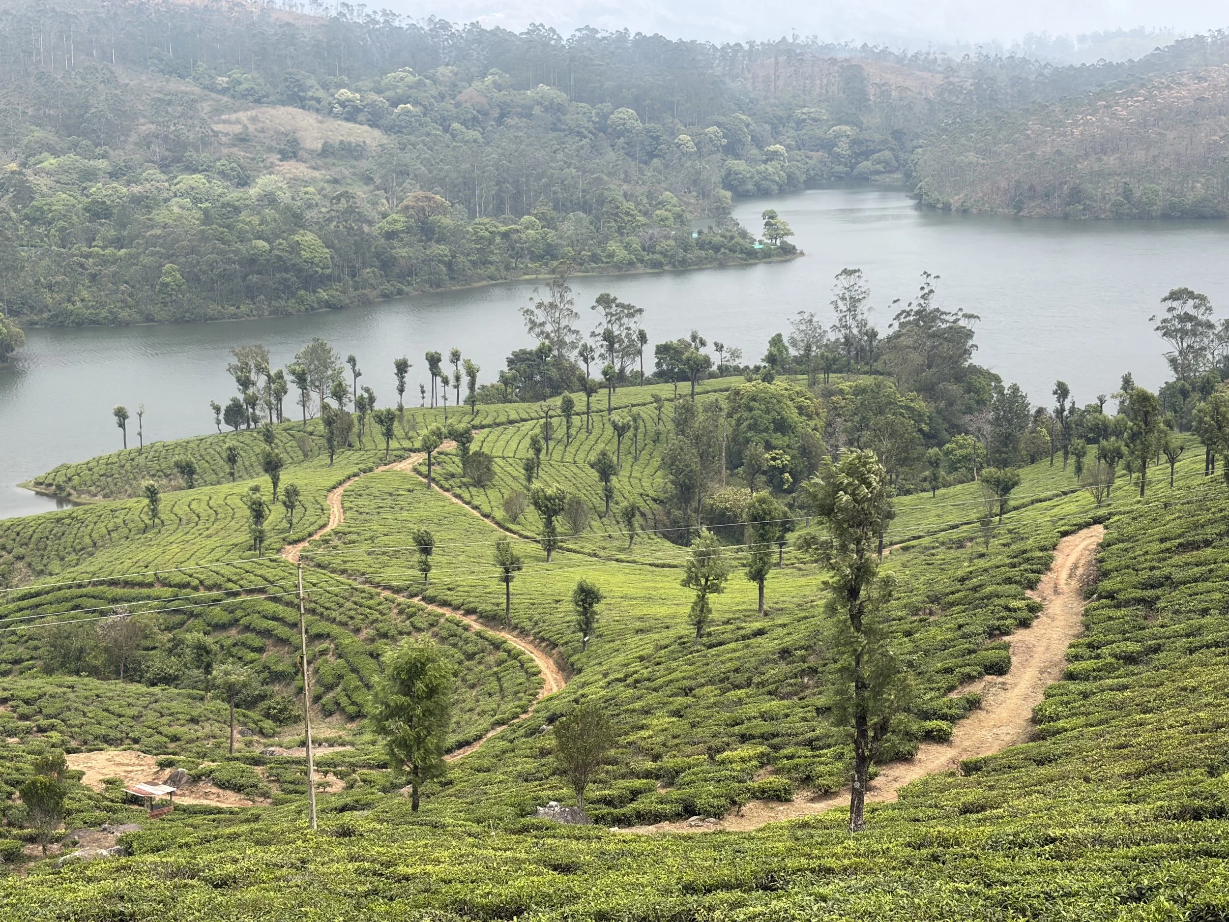
We had to climb up a very large hill to about 1600 and stopped at the top to admire the view and to have a coconut drink which was nice. Once refreshed we drove into the tea area and all the hills wall to floor were covered in tea bushes with a lovely blend of greens mixed with large black boulders here and there. It was very beautiful and it had a large dam -Anayirangal Dam. Anayirangal Dam, is located about 22 km from Munnar in Kerala's Idukki district, is a scenic earthen dam surrounded by Tata tea plantations and evergreen forests. Known as the Elephant Abode Boating Centre and it offers boating and, notably, sights of wild elephant herds that come down to drink water. It looked very scenic when surrounded by tea plantations.
Once we had taken some pics we drove back toward Munnar and it was a bustling city. We stopped for a bite to eat and then headed through the tea plantations to our hotel called Tall Trees – which is the same company as Poetree from Kumily. It is set high up in the trees surrounded by tea plantations. It is a lovely location with a pool, restaurant, gym and games room. We had great rooms in the trees which looked down the valley.
We chilled and relaxed and watched the sunset dip behind the hills. We then showered and had an enjoyable supper in a candlelit type of atmosphere.
We have more adventures tomorrow.
The picture of the day is a view of the Anayirangal Dam with the tea plantations around it.
Need/Opportunity Year Three
In year three I will be going from Thailand to Sri Lanka, India, Maldives and then on to Mauritius, Reunion, Cape Town, St Helena, Azores and back to the UK.
I am looking for crew from Mauritius/ Reunion Island to Cape Town (mid June to end of July) and from Cape Town to the Azores and then to the UK (mid August onwards). If of any interest do email me.
The blog will continue as we continue the journey. If you have any comments or suggestions about the blog then do email me on hine.nick9@gmail.com