Year 3 -15 July 2026 - Cape Town -South Africa
It is 3 years to the day since I left the Hamble in the UK on my circumnavigation. In addition I was called to be informed that my eldest daughter Francesca had got engaged. Many congratulations to her and her fiancée Patrick. May they have a very happy life together.
We woke at a reasonable time and we had scrambled egg on toast for breakfast. The stainless-steel man came to look at the hot water tank and how to secure it better. He had an idea which he will draw out and come back to me. The rigger man came back and showed me the preferred mooring lines which I liked as I need some more and this is a good place to get them. The team to clean Stormbird will come tomorrow morning.
We decided to go out on a hop on bus tour which takes your round the capes. It starts right by the aquarium and not far from when we were moored.
It was a rather grey day and it rained on some of our trip. For those that do not know Cape Town need to understand that it is surrounded by mountains which is part of its attraction and beauty and which has an effect on its weather.
Cape Town is defined by its dramatic mountain ranges, which are part of the Cape Fold Belt. The most famous is Table Mountain, rising 1,086 meters above the city. It is flanked by Devil's Peak to the east and Lion's Head to the west, forming a spectacular natural amphitheatre.
Exploring the mountains of the Cape Peninsula and surrounding winelands offers varied experiences, from casual strolls to rugged, multi-day hikes. Top mountain destinations include:
· Table Mountain: The city's iconic flat-topped peak. You can hike iconic routes like Platteklip Gorge or use the Table Mountain Aerial Cableway to reach the 1,086m summit. Maclear's Beacon sits at the highest point.
· Lion's Head: Rising to 669 meters, this peak is instantly recognizable by its distinct shape. It is famous for its 1.5-hour sunset and full-moon hikes, which offer 360-degree views of the Atlantic Seaboard and the City Bowl.
· The Twelve Apostles: A dramatic mountain range extending south from Table Mountain along the Atlantic coast, featuring a rugged series of buttresses that end above Camps Bay.
· Signal Hill: The lowest of the central peaks (350 meters), stretching seaward and famous for hosting the firing of the Noon Day Gun and offering prime sunset vantage points.
· Constantia Berg: Located further south, this peak rises 927 meters and is renowned for its sweeping views of the Constantia Valley and the southern suburbs.
· Hottentots Holland Mountains: Located about an hour's drive east of the city (near Somerset West), this massive range provides challenging hiking trails and spectacular vistas over the Elgin Valley.
We started the tour on the bus with headphones which provided commentary as we went on our trip. We first of all went along the foreshore which has the conference and business district which then feeds into Long Street from where you can get walking tours of the city. It all looked like a typical city scape but mixed with some old Churches, baths and palm trees. The next stop was the famous Mount Nelson Hotel where dignitaries have stayed and it was then on to the Kirstenbosch Botanical gardens which are famous as was the World of Birds. We came to the Constantia area which is famous for its wines.
Constantia is an affluent residential suburb in the Southern Suburbs of Cape Town, South Africa, situated about 20 kilometres south of the Cape Town CBD. It is considered to be one of the most prestigious suburbs in South Africa, with large, expensive properties attracting affluent residents.
Constantia is also one of the largest neighbourhoods in Cape Town by area. The Constantia Valley lies to the east of and at the foot of the Constantiaberg mountain. Constantia Nek is a low pass linking to Hout Bay in the west.
Constantia is one of the oldest districts of Cape Town and is famed for its wine. The estate of Groot Constantia (Dutch for Great Constantia) was established in 1685 by the Dutch Colonial Governor of Cape Town, Simon van der Stel.
Other notable wine farms in the area include the oldest estate, Steenberg (Dutch for Mountain of Stone), established in 1682, Buitenverwachting (Beyond Expectations), Klein Constantia (Small Constantia) and Constantia Uitsig (View of Constantia). Before the twentieth century, the region was noted for its exports of Vin de Constance; a sweet dessert wine. Many years ago the trade was crippled by the arrival in the Cape of a parasite that attacked the vines.
From the mid-1800s to the 1960s, Constantia remained a rural area of wine estates in which Hottentot, Cape Malay, San and coloured residents constituted the majority. They were farmers, farm workers, domestics and fruit and flower sellers and lived in the areas of Strawberry Lane, Sillery Road, Spaanschemat River Road and Ladies Mile Road.
In 1961 Constantia was zoned as a "White Group Area" under the then-apartheid government's Group Areas Act. In the late 1960s, Constantia inhabitants classified as coloured or black were forcibly removed to areas in the Cape Flats like Mitchell's Plain, Manenberg, and Lotus River.
In 2010, after around 50 years of petitioning, the Solomon family won one of the most successful land claim cases in South Africa's history, and received their Constantia property back with a title deed in 2012. The land was taken from them under the Group Areas Act, and at the time, had 30 houses on it, and the family used it as a thriving agricultural plot.
Mark Thatcher, the son of Margaret Thatcher, and Charles Spencer, 9th Earl Spencer, the brother of Princess Diana, both lived in Constantia. Mark's house is now owned by the Sahara Group. The historic Tarrystone House, once owned by Charles Spencer, 9th Earl Spencer was listed for sale at R80 million.
The area is a major tourist hub. Constantia is a well-known wine-producing area and one of the oldest in the southern hemisphere. It is home to at least ten wine farms, eight of which are included in an official wine route. Numerous operators offer tours of the Constantia wine route where visitors can take part in wine tastings at the farms.
In addition to wine, many Constantia estates also include fine dining restaurants offering both local and international fare. Many of the homesteads along the wine route display Baroque and Cape Dutch architectural styles.
We decided not to stop here today and carried on to Mariners Wharf in Haut Bay.
Hout Bay (Afrikaans: Houtbaai, meaning "Wood Bay") is a seaside and harbour town in the Western Cape province of South Africa. It is situated in a valley of the Cape Peninsula, and is part of the City of Cape Town metro area. The name "Hout Bay" can refer to the town, the bay on which it is situated, or the entire valley.
The area was originally made up of two farms, which were slowly subdivided to make way for urban expansion. While still maintaining its rural atmosphere, the area of Hout Bay has more than 5,960 residences inhabited by a population of at least 17,900 people (as of 2011).
From remains found in a cave, we know that people lived in this cave between 100 AD and 500 AD. These people were known as the Late Stone Age people. They had no metal tools or weapons and used stone to make whatever implements they needed. They were gatherers of wild plants, shellfish and the seabirds and animals that were washed ashore. They also hunted and fished using hooks fashioned from bones and nets made from fibrous plants and the skins of animals.
The Khoi-Khoi and Bushmen were descendants of the late Stone Age people. They were called Khoi-Khoi because of the clicking sounds contained within their language. The Khoi-Khoi were also called Strandlopers because they gathered food from the beaches. Some people also referred to them as Kaapmans, Men from the Cape. The Khoikhoi were gatherers, hunters and herders, which meant that apart from gathering and hunting for food, they also possessed large herds of cattle and sheep. They lived in huts made of restio mats tied to a Beehive shape frame made of pliable poles. The Khoi traded with the early voyagers from Europe who were on their way to the East and had stopped at the Cape in order to get fresh food and water. The Khoi bartered with these early sailors exchanging cattle and sheep for small pieces of copper, brass and tin.
John Chapman, masters mate on the English boat, the "Consent" which was becalmed at the entrance to the Bay, was sent in the ship's pinnace at dusk on a chancy venture because Hout Bay was unknown wild country and the time was late afternoon which would make it difficult for him to find the Consent in the darkness.
Recorded in the Rutter (Logbook) by the pilot, John Davis: "Chapman’s Chaunce hath in latitude 34-10 and is a harbour which Leith within the south-west point under a little hill like charring cross (a sculptured memorial of a cross on an ornamental mounting in London) close hanging by the seaside of the S.S.W side of the land " Chapmans Chaunce was the first name given to Hout Bay and it was also the first English name to appear on the maps of Southern Africa. In 1614 an English sailor records having taken wood from the forest of Hout Bay in order to mend his ship.
In 1781 the French built three forts at Hout Bay. These were part of a line of forts known as the French lines that were built in order to protect the Cape from falling into the hands of the English. In 1873, manganese was discovered in the Constantiaberg. In 1909 to 1911 manganese was mined in Hout Bay. Reminders of these activities are the ruins of the manganese ore jetty and the old mine workings up the mountain. In 1880, Crisp Arnold set up fishing sheds and started curing snoek for export to Mauritius.
In 1895 Walter Gurney built the first church in Hout Bay. It still stands today and is known as St Peter's the Fisherman. The first school in Hout Bay was started in this church.
In 1904 Hout Bay's first crawfish canning factory was established in the wreck of an old sailing ship, The R Morrow that stood where the present South African Sea Products factory is today. For almost 10 years the factory operated successfully exporting canned crawfish overseas and providing work for the local inhabitants. On 31 July 1914 a leak in the acetylene gas supply caused an explosion which blew up the canning factory.
Chapman's Peak
In 1922 Chapman's Peak Drive was opened to the public. It had been built by the provincial administration using convict labour. It had taken 7 years to build and had cost (R40 000).
German immigrant and farmer Jacob Trautmann established the first fishing village here in 1867. The fishing industry expanded substantially in the 1930s when fish became a popular item on menus and improved facilities for transporting fish inland were created. The Trautmann family improved their fishing boats and built more sheds on the beach for processing the fish. They owned Trans Africa Fisheries. The Trautmann brothers introduced the valuable frozen rock lobster tail export business and the Dorman family, who like the Trautmanns, had originally bought land in the 19th century for farming purposes became more involved in the fishing industry. Duikersklip and Chapman's Peak Fisheries were two companies owned by the Dormans.
Today Chapman's Peak fisheries have expanded to incorporate a fish importing business as well as retailing local catches. Mariners Wharf, South Africa's fish emporium, was opened 1984.
Harbour facilities have improved steadily over the years. In 1937 the South Breakwater was built and in 1968 the North Breakwater was added. The post-war fishing factories spread everywhere and at Hout Bay, the South African Sea Products Company was established.
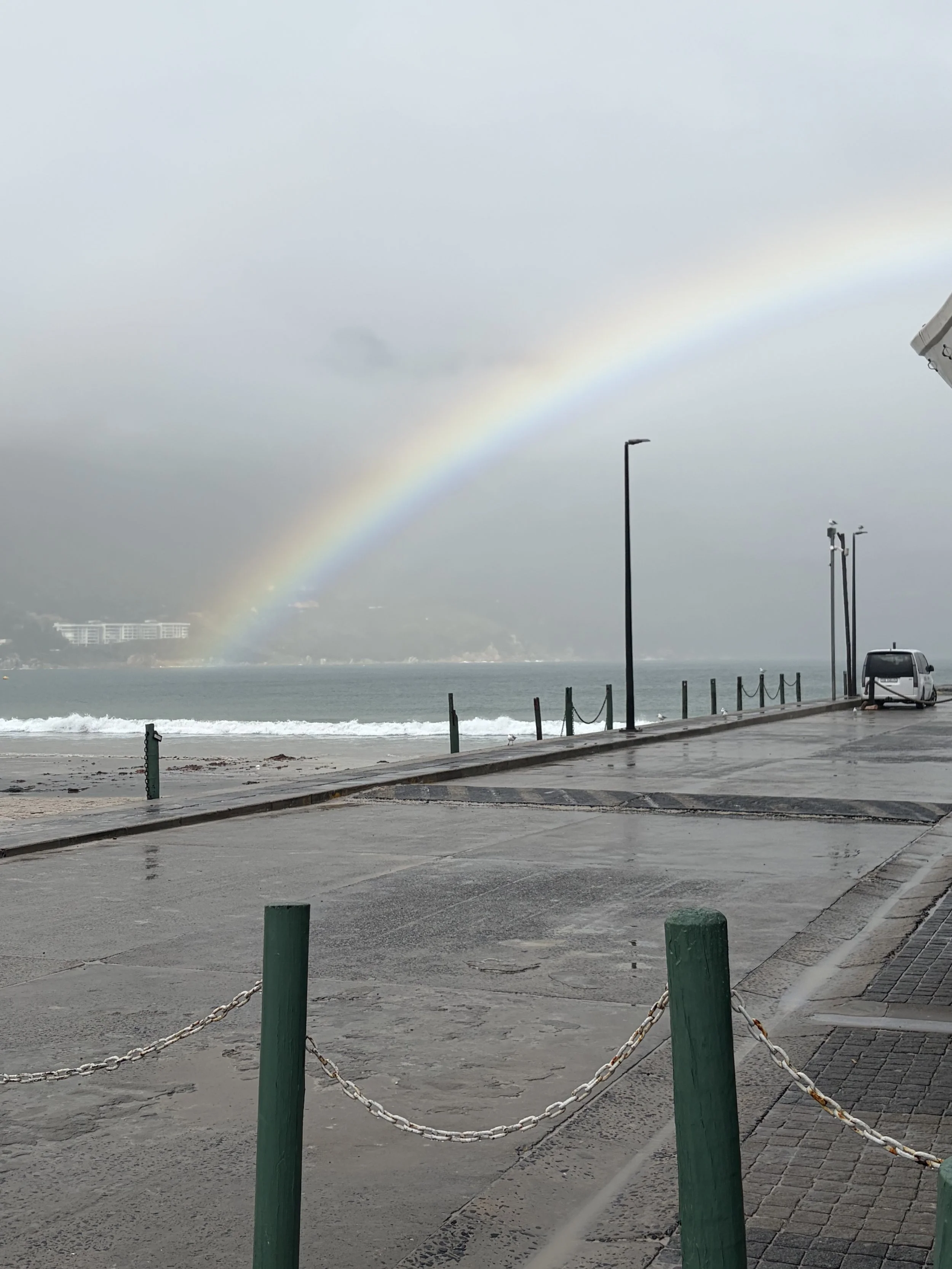
We got out at Mariners Wharf and could see the beach and bay in front of us which had a rainbow over it as it had been raining. There was a seal on the quay and we went up the stairs into a lovely old seafarers’ restaurant which was full of old wood and boat memorabilia. We had an Old Sea Dog larger which I felt was very apt as it was the 3rd anniversary since I left the Hamble on Stormbird. We had a great lunch and then got back on the bus which took us to the distillers in Hout Bay (we did not stop) and then on to Camp’s Bay.
Camps Bay (Afrikaans: Kampsbaai) is an affluent suburb of Cape Town, South Africa, and the small bay on the west coast of the Cape Peninsula after which it is named. It is one of 10 suburbs that form the city's Atlantic Seaboard. In summer, Camps Bay attracts many locals, and foreign visitors.
It has a number of beach areas.
Oudekraal is made up of a collection of tiny beaches sheltered amongst the boulders and a well-established picnic area with lawns, Braais, covered seating areas with tables, benches and public toilets.
Lui Bay (also known as Witsand) is a popular dive site. In 1977 two scrap vessels, the Antipolis and Romelia, were being towed around the cape when their tow line broke in a storm. This caused the Antipolis to run aground near Oudekraal, while the Romelia ran aground further south on Sunset Rocks at Llandudno. The wreck of the Antipolis was cut down to about low water level, but part of the hull was cast up on the beach by a storm,
Koeël Bay has an African open-air curio market that sells hand crafted items from all over Africa.
Bakoven gets its name because of a large rock just offshore with what appears as an oven door in its side. There are several sheltered coves located in Bakoven. There is a sea rescue base stationed here and a popular swimming beach is off Beta Close. In the 1940s a row of beach front houses were erected to house honoured members of the South African Army who fought during World War II. Many of these old houses still stand and are now registered as South African National Heritage Sites.
Balie Bay, from the Afrikaans kak balie (shit barrel) after the sewer discharge that used to be there.
Camps Bay Beach, a Blue Flag Beach since 2008, is the largest white sand beach in Camps Bay. There is a seasonal lifeguard station with toilets at the west end of the beach. The beach is opposite Camps Bay's main tourist hub, featuring multiple hotels, restaurants, and shops.
Glen Beach, at the far right of Camps Bay beach, is known as Camps Bay's best surfing beach.
We continued and eventually came back to Green Point and its famous lighthouse and then on to Cape Town again. The trip led us round the amphitheatre of mountains I described above. Although the weather was not great we had seen a lot and the coastline is impressive and beautiful.
We had eaten enough and so went out to see the England V Argentina game. I shall say no more.
Otherwise it had been an enjoyable day.
The picture of the day is of the rainbow in Haut Bay. You can see how poor the weather was but we still enjoyed it.
Need/Opportunity Year Three
I am now on the way to Durban and will then head for Cape Town and then on to St Helena, Azores and back to the UK.
I am now in need of 1 additional crew from Cape Town to the Azores. The new crew member would need to be onboard by 10 August and it is likely we would get to the Azores by late September or early October. If at all interested in joining me please contact me on my email below or WhatsApp +44 7931360372.
The blog will continue as we continue the journey. If you have any comments or suggestions about the blog then do email me on hine.nick9@gmail.com