Year 3 -13 July 2026 - Cape Town -South Africa
We woke at about 8.30 am having gone to bed about 4.00am. It was a cold grey day and I decided we needed a cooked breakfast which I then made which set us up for the day. This was enjoyed by all.
They were pressure washing the pontoon when we woke to clear the bird droppings and I thought it is a bit like the Forth Bridge -once you finish painting it you have to start again!
I went off the marina office and the guys started the clean up process after our passage. I met the marina manager and had a good chat. He said as long as your stay in the Waterfront area you are safe but do not go outside it at night.
The V&A Waterfront, often referred to as The Waterfront and The V&A, is a mixed-use suburb in Cape Town, South Africa, featuring upmarket residential apartments, a major shopping mall, a marina, and multiple large hotels.
The Waterfront sits on the site of the oldest working harbour in the Southern Hemisphere. With Table Mountain as its backdrop, the 123-hectare neighbourhood sees millions of people visiting each year. The V&A Waterfront is Cape Town's most popular tourist destination by number of visitors per year.
The mall is one of Cape Town's largest, and the Waterfront features numerous other retail spaces, including the Watershed, and Alfred Mall. Waterfront apartments in the foreground and Signal Hill in the background Two Oceans Aquarium and Victoria & Alfred Waterfront Swing Bridge.
The V&A also houses the Cape Business Centre for conferences, and Workshop 17 for coworking.
The V&A Waterfront is a central part of the very beginning of the settlement of the city of Cape Town. In 1654, two years after his arrival in this relatively safe bay at the foot of Table Mountain, Jan van Riebeeck built a small jetty as part of his task to establish a refreshment station at the Cape. Fresh water and fresh produce were provided to the ships of the Dutch East India Company on their arduous and lengthy journey to their outposts in Java and Batavia. The sea and the harbour lie at the heart of Cape Town's history.
In June 1858, serious winter storms, which were a common occurrence, wrecked over 30 vessels. As a consequence, Lloyds of London refused to cover ships spending the winter in Table Bay. On a sunny day in September 17, 1860, Midshipman HRH Prince Alfred, Queen Victoria's second son, tipped the first load of stone to start construction of the breakwater for Cape Town's first harbour to make it a safe haven all year round for passing ships.
In 1984, Sol Kreiner, Mayor of Cape Town, advanced what would become the V&A Waterfront by forming a steering committee to consider a waterfront scheme: "As Johannesburg has gold, we have a beautiful city as a tourist attraction and we must all work together for a better Cape Town. We have a large cross-section of people who are prepared to sit down and discuss a scheme which will bring back the old city where one can freely walk around, visit the harbour, go for tug rides and learn more about our heritage.” Kreiner later became the council-nominated director on the board of the Victoria and Alfred Waterfront Company.
The discovery of gold and diamonds in South Africa meant that the first section of harbour, the Alfred Basin, was not large enough to accommodate the increased number of ships, and the Victoria Basin was built. The construction of these two harbour basins took place between 1860 and 1920, and this area of the harbour still has an array of outstanding heritage buildings from this era.
In 1938 work was started to reclaim land between the city centre and the harbour, most notably the new Duncan Dock. The Foreshore (230 hectares) made city expansion possible. In the early 20th century, South Africa depended mainly on imports for many basic articles in daily use, which explains the importance of the harbour to the people who lived here.
In November 1988, Victoria and Alfred Waterfront (Pty) Ltd was established as a wholly owned subsidiary by Transnet Ltd. Its aim was to redevelop the historic docklands around the Victoria and Alfred Basins as a mixed-use area with a focus on retail, tourism and residential development with a working harbour at its centre. Today it is a mixed-use development that spans 23 hectares, with 24 million visitors a year. Over 23 000 people work and live within its neighbourhood.
Cape Town is the legislative capital of South Africa. It is the country's oldest city and the seat of the Parliament of South Africa. Cape Town is the country's second-largest city by population, after Johannesburg, and the largest city in the Western Cape. The city is part of the City of Cape Town metropolitan municipality.
The city is known for its harbour, its natural setting in the Cape Floristic Region, and for landmarks such as Table Mountain and Cape Point. Located on the shore of Table Bay, the City Bowl area of Cape Town, which contains its central business district (CBD), is the oldest urban area in the Western Cape, with a significant cultural heritage. The metropolitan area has a long coastline on the Atlantic Ocean, which includes a northern section in the West Beach region, as well as the False Bay area in the south.
The Table Mountain National Park is within the city boundaries and there are several other nature reserves and marine-protected areas within and adjacent to the city. These include Kirstenbosch National Botanical Garden, which contains 5 of South Africa's 6 biomes, and displays many plants native to the Cape region.
A popular global tourist destination, Cape Town has been named the best city in the world, and the world's best city for travellers numerous times, including by The New York Times in 2014, Time Out in 2025, and The Telegraph for the past 8 years (2017 through 2025). Cape Town has South Africa's highest household incomes, lowest rate of unemployment, highest level of infrastructure investment, strongest service delivery performance, largest tourism appeal, and most robust real estate market.
Portuguese explorer Bartolomeu Dias planting the cross at Cape Point, 1488. The earliest known remnants of human occupation in the region were found at Peers Cave in Fish Hoek in the late 1920s. Subject to much debate, earlier estimations as to an upper Pleistocene origin have since been revised.
Bartolomeu Dias, the first European to reach the area, arrived in 1488 and named it "Cape of Storms" (Cabo das Tormentas). It was later renamed by John II of Portugal as "Cape of Good Hope" (Cabo da Boa Esperança) because of the great optimism engendered by the opening of a sea route to the Indian subcontinent and East Indies. In 1497, Portuguese explorer Vasco da Gama recorded a sighting of the Cape of Good Hope.
In 1510, at the Battle of Salt River, the Portuguese admiral Francisco de Almeida and sixty-four of his men were killed and his party was defeated by the "Goringhaiqua" (in Dutch approximate spelling) using cattle that were specially trained to respond to whistles and shouts.
The Gorinaiqua were one of the Khoikhoi clans who inhabited the area. In the late 16th century French, Danish, Dutch, and English, but mainly Portuguese, ships regularly continued to stop over in Table Bay en route to the Indies. They traded tobacco, copper, and iron with the Khoikhoi clans of the region in exchange for fresh meat and other essential traveling provisions.
With the Dutch Republic being transformed into Revolutionary France's vassal Batavian Republic, Great Britain moved to take control of Dutch colonies, including the colonial possessions of the VOC.
Britain captured Cape Town in 1795, but it was returned to the Dutch by treaty in 1803. British forces occupied the Cape again in 1806 following the Battle of Blaauwberg when the Batavian Republic allied with Britain's rival, France, during the Napoleonic Wars. Following the conclusion of the war Cape Town was permanently ceded to the United Kingdom in the Anglo-Dutch Treaty of 1814.
The city became the capital of the newly formed Cape Colony, whose territory expanded very substantially through the 1800s, partially as a result of numerous wars with the amaXhosa on the colony's eastern frontier. In 1833 slavery was abolished in the colony freeing over 5500 slaves in the city, almost a third of the city's population at the time. The Convict Crisis of 1849, marked by substantial civil upheaval, bolstered the push for self-governance in the Cape.
With expansion came calls for greater independence from the UK, with the Cape attaining its own parliament (1854) and a locally accountable prime minister (1872). Suffrage was established according to the non-racial Cape Qualified Franchise.
During the 1850s and 1860s, additional plant species were introduced from Australia by the British authorities. Notably rooikrans was introduced to stabilise the sand of the Cape Flats to allow for a road connecting the peninsula with the rest of the African continent and eucalyptus was used to drain marshes.
In 1859 the first railway line was built by the Cape Government Railways and a system of railways rapidly expanded in the 1870s. The discovery of diamonds in Griqualand West in 1867, and the Witwatersrand Gold Rush in 1886, prompted a flood of immigration into South Africa. In 1895 the city's first public power station, the Graaff Electric Lighting Works, was opened.
Conflicts between the Boer republics in the interior and the British colonial government resulted in the Second Boer War of 1899–1902. Britain's victory in this war led to the formation of a united South Africa. From 1891 to 1901, the city's population more than doubled from 67,000 to 171,000.
As the 19th century came to an end, the economic and political dominance of Cape Town in the Southern Africa region during the 19th century started to give way to the dominance of Johannesburg and Pretoria in the 20th century.
In 1910 Britain established the Union of South Africa which unified the Cape Colony with the two defeated Boer Republics and the British colony of Natal. Cape Town became the legislative capital of the Union, and later of the Republic of South Africa.
By the time of the 1936 census, Johannesburg had overtaken Cape Town as the largest city in the country.
In 1945 the expansion of the Cape Town foreshore was completed, adding an additional 194 ha (480 acres) to the Cape Town CBD, and by extension, the City Bowl region.
Prior to the mid-twentieth century Cape Town was one of the most racially integrated cities in South Africa. In the 1948 national elections the National Party won on a platform of apartheid (racial segregation) under the slogan of "swart gevaar" (Afrikaans for "black danger"). This led to the erosion and eventual abolition of the Cape's multiracial franchise.
In 1950 the apartheid government first introduced the Group Areas Act, which classified and segregated urban areas according to race. Formerly multi-racial suburbs of Cape Town were either purged of residents deemed unlawful by apartheid legislation, or demolished. The most infamous example of this in Cape Town was the suburb of District Six. After it was declared a whites-only area in 1965, all housing there was demolished and over 60,000 residents were forcibly removed. Many of these residents were relocated to the Cape Flats.
The earliest of the Cape Flats forced removals saw the expulsion of Black South Africans to Langa, Cape Town's first and oldest township, in line with the 1923 Native Urban Areas Act.
Under apartheid the Cape was considered a "Coloured labour preference area", to the exclusion of "Bantus", i.e. Black Africans. The implementation of this policy was widely opposed by trade unions, civil society and opposition parties. It is notable that this policy was not advocated for by any Coloured political group, and its implementation was a unilateral decision by the apartheid government.
During the student-led Soweto Uprising of June 1976, school students from Langa, Gugulethu and Nyanga in Cape Town reacted to the news of the protests against Bantu Education by organising gatherings and marches of their own. A number of school buildings were burnt down and the protest action was met with forceful resistance from the police.
Cape Town has been home to many leaders of the anti-apartheid movement. In Table Bay, 10 km (6 mi) from the city is Robben Island. This penitentiary island was the site of a maximum-security prison where many famous apartheid-era political prisoners served long prison sentences. Famous prisoners include activist, lawyer and future president Nelson Mandela who served 18 of his 27 years of imprisonment on the island, as well as two other future presidents, Kgalema Motlanthe and Jacob Zuma. We passed Robin Island on the way in last night.
In one of the most famous moments marking the end of apartheid, Nelson Mandela made his first public speech since his imprisonment from the balcony of Cape Town City Hall, hours after being released on 11 February 1990. His speech heralded the beginning of a new era for the country. The first democratic election was held four years later on 27 April 1994.
Nobel Square in the Victoria & Alfred Waterfront features statues of South Africa's four Nobel Peace Prize winners: Albert Luthuli, Desmond Tutu, F. W. de Klerk and Nelson Mandela.
Cape Town has undergone significant changes in the years since Apartheid. Cape Town has experienced economic growth and development in the post-apartheid era. The city has become a major economic hub in South Africa, attracting international investment and tourism. The Democratic Alliance (DA), a liberal political party which came to power in Cape Town in 2006, has been credited with improving bureaucratic efficiency, public safety and fostering economic development.
Opinion polls show that South Africans view the Western Cape as the best governed province, Cape Town as the best governed city in the country. Of South Africa's 257 municipalities, only 38 received a clean financial audit in 2022 from the Auditor-General. Of those, 21 were in the Western Cape.
The city's economy has diversified, with growth in sectors such as technology, finance, real estate, and tourism. The establishment of the Cape Town CCID has been particularly successful in revitalizing the city centre, bringing businesses and people back into the area. This initiative has transformed public spaces such as Greenmarket Square, Company's Garden, and St George's Mall, attracting both locals and tourists.
In 2014 Cape Town was named World Design Capital of the Year. Cape Town was voted the best tourist destination in Africa at the 2023 World Travel Awards in Dubai and continues to be the most important tourist destination in the country. Cape Town has been named the best travel city in the world every year since 2013 in the Telegraph Travel Awards.
Rapid urbanization driven by migration from the Northern and Eastern Cape, along with the legacy of apartheid's spatial planning, have caused significant disparities between affluent areas and impoverished townships. 60% of the city's population live in townships and informal settlements far from the city centre. The legacy of Apartheid means Cape Town remains one of the most racially segregated cities in South Africa. Many Black South Africans continue to live in informal settlements with limited access to basic services such as healthcare, education, and sanitation.
The unemployment rate in Cape Town remains high at 23% as of 2024 (though nearly 10 points lower than the nationwide average), particularly among historically disadvantaged groups, and economic opportunities are unevenly distributed.
Table Mountain, with its near vertical cliffs and flat-topped summit over 1,000 m (3,300 ft) high, and with Devil's Peak and Lion's Head on either side, together form a dramatic mountainous backdrop, which creates the City Bowl. This area comprises the Cape Town CBD as well as numerous suburbs on the mountainside.
A thin strip of cloud, known colloquially as the "tablecloth" ("Karos" in Afrikaans), sometimes forms on top of the mountain. To the immediate south of the city, the Cape Peninsula is a scenic mountainous spine jutting 40 km (25 mi) southward into the Atlantic Ocean and terminating at Cape Point.
There are over 70 peaks above 300 m (980 ft) within Cape Town's official metropolitan limits. Many of the city's suburbs lie on the large plain called the Cape Flats, which extends over 50 km (30 mi) to the east and joins the peninsula to the mainland. The Cape Town region is characterised by an extensive coastline, rugged mountain ranges, coastal plains and inland valleys.
The extent of Cape Town has varied considerably over time. It originated as a small settlement at the foot of Table Mountain and has grown beyond its city limits as a metropolitan area to encompass the entire Cape Peninsula to the south, the Cape Flats, the Helderberg basin and part of the Steenbras catchment area to the east, and the Tygerberg hills, Blouberg and other areas to the north. Robben Island in Table Bay is also part of Cape Town. It is bounded by the Atlantic Ocean to the west, and False Bay to the south. To the north and east, the extent is demarcated by boundaries of neighbouring municipalities within the Western Cape province.
The Cape Peninsula is 52 km (30 mi) long from Mouille Point in the north to Cape Point in the south, with an area of about 470 km2 (180 sq mi), and it displays more topographical variety than other similar sized areas in southern Africa, and consequently spectacular scenery. There are diverse low-nutrient soils, large rocky outcrops, scree slopes, a mainly rocky coastline with embayed beaches, and considerable local variation in climatic conditions.
The sedimentary rocks of the Cape Supergroup, of which parts of the Graafwater and Peninsula Formations remain, were uplifted between 280 and 21S million years ago, and were largely eroded away during the Mesozoic. The region was geologically stable during the Tertiary, which has led to slow denudation of the durable sandstones. Erosion rate and drainage has been influenced by fault lines and fractures, leaving remnant steep-sided massifs like Table Mountain surrounded by flatter slopes of deposits of the eroded material overlaying the older rocks,
There are two internationally notable landmarks, Table Mountain and Cape Point, at opposite ends of the Peninsula Mountain Chain, with the Cape Flats and False Bay to the east and the Atlantic Ocean to the west. The landscape is dominated by sandstone plateaux and ridges, which generally drop steeply at their margins to the surrounding debris slopes, interrupted by a major gap at the Fish Hoek–Noordhoek valley.
In the south much of the area is a low sandstone plateau with sand dunes. Maximum altitude is 1113 m on Table Mountain. The Cape Flats (Afrikaans: Kaapse Vlakte) is a flat, low-lying, sandy area, area to the east the Cape Peninsula, and west of the Helderberg much of which was wetland and dunes within recent history. To the north are the Tygerberg Hills and the Stellenbosch district.
UNESCO declared Robben Island in the Western Cape a World Heritage Site in 1999. Robben Island is located in Table Bay, some 6 km (3.7 mi) west of Bloubergstrand, a coastal suburb north of Cape Town, and stands some 30m above sea level. Robben Island has been used as a prison where people were isolated, banished, and exiled for nearly 400 years. It was also used as a leper colony, a post office, a grazing ground, a mental hospital, and an outpost.
The Cape Peninsula is a rocky and mountainous peninsula that juts out into the Atlantic Ocean at the south-western extremity of the continent. At its tip is Cape Point and the Cape of Good Hope. The peninsula forms the west side of False Bay and the Cape Flats. On the east side are the Helderberg and Hottentots Holland mountains.
Cape Town has a Mediterranean climate, with mild, moderately wet winters and dry, warm summers. Winter, which lasts from June to September, may see large cold fronts entering for limited periods from the Atlantic Ocean with significant precipitation and strong north-westerly winds. Winter months in the city average a maximum of 18 °C (64 °F) and minimum of 8.5 °C (47 °F).
I had emailed Des to say we had arrived safely and he replied;
Dear Nick & co
Excellent news and extremely pleased you are safe in Cape Town. You are the first of the 2026 crowd and you have set a standard which in all probability will be unmatched. I usually give yachties a couple of days to "detox" before sending out the begging bowl but my standard shpiel follows.
Best wishes as always
Des
I then set about getting on to things being resolved. I messaged the rigger who will send someone tomorrow to start the process. I messaged the water maker man and battery man and they will get back to me. I found the yacht services man about giving the grp on Stormbird a clean and also to sort out the calorifier which had slipped its brackets in the swell and to fill the gas bottle. I had also messaged the local OSRSA agent who said he would come to see us. I messaged the Volvo agent to service the engine and to check the temperature and oil sensors.
Once we had done various jobs etc we decided to go out for lunch and went to Quay 4. The Waterfront here is a world on its own and is full of shops, restaurants, cafes, supermarkets etc. It is also safe and really you do not need to leave if you do not want to. When walking to the restaurant we observed this and saw a group of youngsters singing and dancing with Africa music which was heart lifting. We saw seals in the marina and on an area of a jetty. Why they come in here I do not know.
We had a great lunch and returned to Stormbird for 3.30am as we were meeting the OSRSA representative. Robert Ravensburg. He came to say hello and to offer any help we needed. He suggested we go to Immigration so that we can check in with them. Technically we did not need to do it but he suggested it will be helpful when we come to leave. He therefore took me off in the car to do what we needed and I registered with them.
Hisham came to visit and we had some tea and the remainder of Keith’s cake. He had spent a few days in Cape Town and was flying to Cairo tomorrow. It was good to see him and we had a laugh.
As we were full we decided to stay in and have cheese and biscuits with some Cote de Rhone we had bought which we called Cotes du Ron!! It was so cold I put the heating on in the boat and we were soon toasty and warm.
We had had a good long day and we were here which felt a bit like the end of a chapter. We went to be needing to catch up on some sleep.
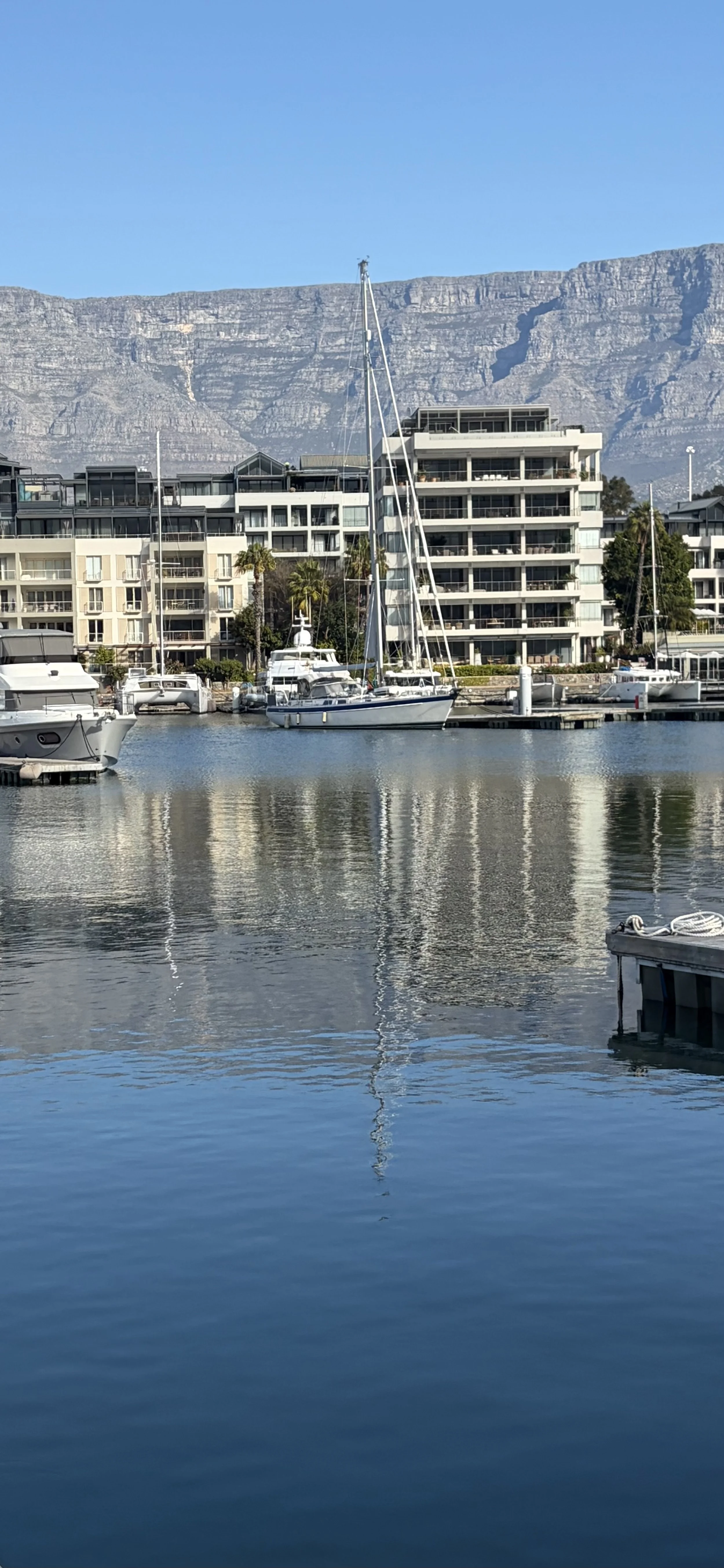
The picture of the day is of Stormbird moored with Table Mountain in the background. An iconic picture.
Need/Opportunity Year Three
I am now on the way to Durban and will then head for Cape Town and then on to St Helena, Azores and back to the UK.
I am now in need of 1 additional crew from Cape Town to the Azores. The new crew member would need to be onboard by 10 August and it is likely we would get to the Azores by late September or early October. If at all interested in joining me please contact me on my email below or WhatsApp +44 7931360372.
The blog will continue as we continue the journey. If you have any comments or suggestions about the blog then do email me on hine.nick9@gmail.com