Year 2- 25th October 2025 –South China Sea on way to -Nongsa Marina Batam
I was woken about 00.30 hours by the engine appearing to labour and some rolling and went up to the cockpit to find we were in the middle of a tropical rainstorm. It was raining very heavily and the wind was blowing 35 kts and had been up to 42 kts in gusts. There were large waves we were motoring into and the wind was on the nose hence why the engine was struggling in gori to move us forward with any speed. The waves were crashing over the deck and I could hear the deck drains gurgling and struggling to get rid of the water. I put my life jacket on and Mark was doing his best to keep us on course. The first thing I did was to change from the gori to normal propeller angle. This provides more drive and once can increase revs more easily. I then thought about coming off the wind a bit so we were not bashing straight into the waves and could ride over them more. This seemed to help and made the motion better.
Ruth spotted that the Blue Baron was coming a little loose. It was tied to the guard rails on the starboard side and with the wind and waves crashing over it was coming out of the snuffer hat. If we allowed it to continue then it could go over the side and that would cause a problem. It would be difficult to get back and could go into the propeller. Ruth and I went up twice with ties and ropes and tied it down more securely. Whilst we were doing this we were sprayed several times by the waves which felt like being hit by buckets of lukewarm bathwater as the water was so warm in comparison to the rain. In short we got soaked. I waited with Ruth and Mark until they handed over to Keith and Steve. We had been watching the rain on the radar which was all around us. We were only able to motor at about 3-4 kts depending on the waves.
After about an hour I could do no more as I was on at 5.00am. Keith and Steve were motoring forward and in control of the conditions so I climbed out of my wet clothes and went to bed. I woke at 4.50am and we were now out of the rain and motoring about 6.5 kts and on course. There was still a little swell but no rain. Andy and I took over and we decided to go back into gori propeller angle which increased our speed and fuel efficiency. It began to get light and we were on course again. The storm had delayed us by a few hours.
My plan was to go through the channel between Tanjung Barat and Pulau Batam called the Tanjung Uban Tambelan channel. This meant from where we were that we had about 42 nm to go. We motored on and noticed on AIS that a number of cargo ships and oil carriers used this channel and there were two lots of tugs towing large barges as well. It was a warm but cloudy day and it was as if the air had cleared after the storm. We motored on through the channel changing course as we reached the set waypoints I had placed showing the route through the channel.
There were lots of little islands dotted here which looked pretty and there and a number of posts and buoys in the water demarcating the channel from shallow areas.
We handed over to Mark and Ruth again at 8.00am and I went to get some sleep and I woke as we were coming out of the channel into the Singapore straits. On AIS it looked like worker ants going about their business as there were so many ships going back and forth. They think that at least 2,000 ships pass through here a day and about 40 % of the world’s trade.
The Singapore Strait is a vital and busy waterway connecting the Strait of Malacca to the South China Sea, bordered by Singapore to the north and Indonesia's Riau Islands to the south. It is a crucial shipping lane for global trade and is notable for the high volume of ship traffic (about 2,000 ships a day) that passes through it daily. The strait is a geographically strategic site that has been historically important for trade and has been a site of strategic importance and conflict for centuries. The strait is located at the southern tip of the Malay Peninsula, separating Singapore from the Riau Islands of Indonesia. It is about 114 km long and narrows to a minimum width of 16km. It is one of the most important shipping lanes in the world, as it handles a significant portion of global seaborne trade and crude oil. The strait is a key connection for ships traveling between the Indian Ocean and the South China Sea. The strait forms a maritime border between Singapore and Indonesia, with both countries sharing a border along its waters.
Once through the Singapore Strait we enter the Malacca Strait. The Strait of Malacca is a narrow stretch of water, 900 kilometres (560 mi) long and from 65 to 250 km (40 to 155 mi) wide, between the Malay Peninsula to the northeast and the Indonesian island of Sumatra to the southwest, connecting the Andaman Sea (Indian Ocean) and the South China Sea (Pacific Ocean). As the main shipping channel between the Indian and Pacific oceans, it is one of the most important shipping lanes in the world. The strait is the main shipping channel between the Indian Ocean and the Pacific Ocean, linking major Asian economies such as India, Thailand, Indonesia, Malaysia, Philippines, Singapore, Vietnam, China, Japan, Taiwan, and South Korea. The Strait of Malacca is part of the Maritime Silk Road that runs from the Chinese coast towards the southern tip of India to Mombasa, from there through the Red Sea via the Suez Canal to the Mediterranean, there to the upper Adriatic region to the northern Italian hub of Trieste with its rail connections to Central Europe and the North Sea. Over 94,000 vessels pass through the strait each year (2008- it will be way more now) making it the busiest strait in the world, carrying about 25% of the world's traded goods, including oil, Chinese manufactured products, coal, palm oil and Indonesian coffee. About a quarter of all oil carried by sea passes through the strait, mainly from Persian Gulf suppliers to Asian markets. In 2007, an estimated 13.7 million barrels per day were transported through the strait, increasing to an estimated 15.2 million barrels per day in 2011. In addition, it is also one of the world's most congested shipping choke points because it narrows to only 2.8 km (1.5 nautical miles) wide at the Phillip Channel (close to southern Singapore).
We therefore have some interesting and difficult passages to undertake when we leave Indonesia and proceed up to Thailand. As we were motoring on to Batam we had some messages come up on the plotter warning of piracy which has been increasing recently on the Singapore side. This seemed a bit odd so we will have to be on the lookout for wayward boats.
Once we were out of the channel we turned west along Batam Island and about 11.00am we were approaching the marina. A catamaran called Oracle came very close on a similar course and showed no heed to the collision regulations so I eased off and let him go. What a ….. – you still come across them from time to time.
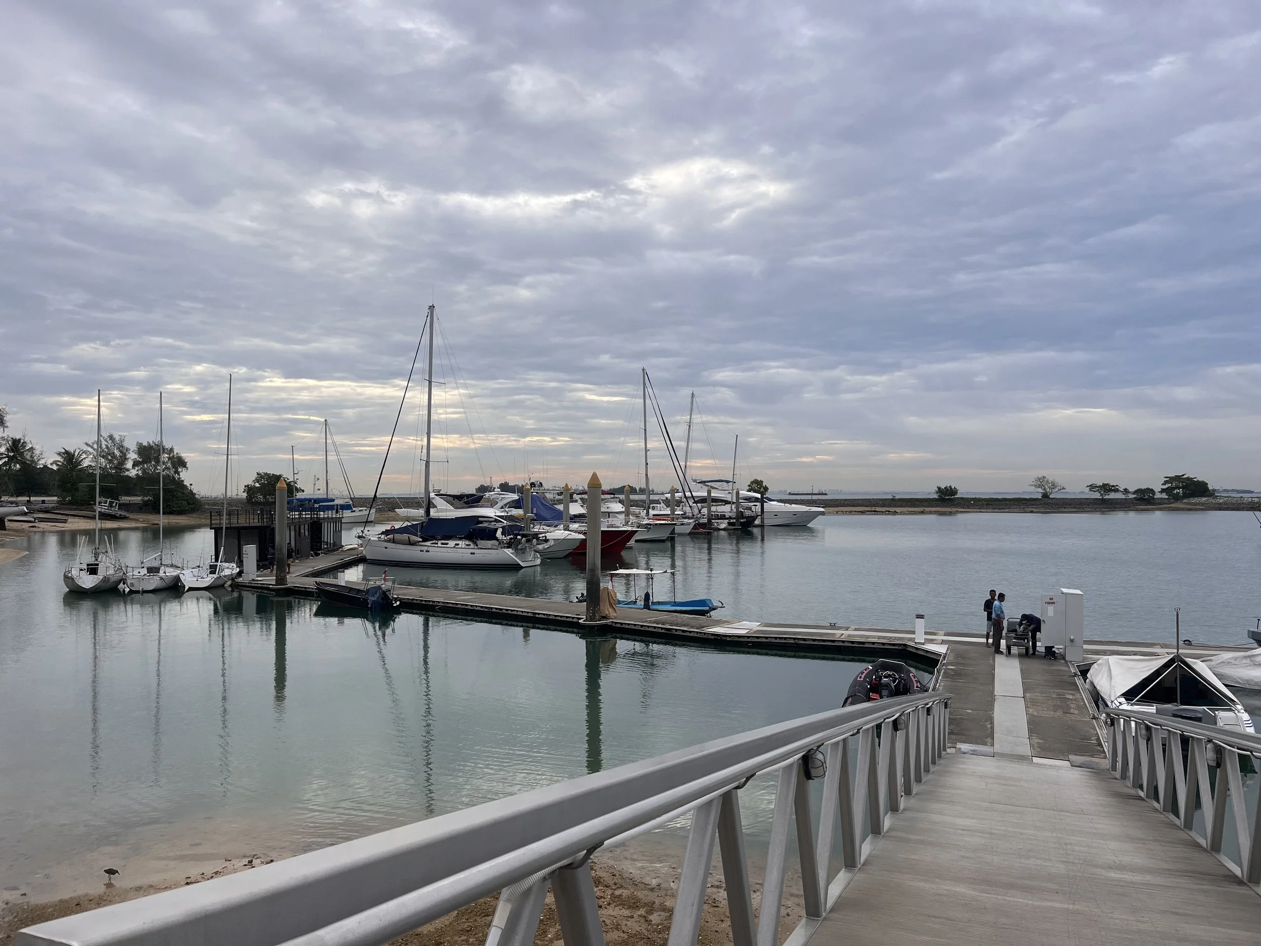
We motored into the Nongsa Point Marina where we had a reserved berth and were then moored about 11.30am. It was a small marina with three large pontoons with houses and villas around it. It had a swimming pool, a restaurant, laundry, showers and toilets and it was from where they were organising our check out from Indonesia. We had travelled 321nm (53.5 hours) since Belitung and had encountered two tropical rainstorms on route. We had sailed the first day but had had to motor quite a lot to get here in the right timeframe and we had crossed the equator. We were here safe and sound ready for our next chapter.
We got ourselves settled, had a welcome beer and then went to the marina office where they took our passports and original documents. They should get everything back tomorrow and we should then be free to leave on the 27th for Malaysia.
We had eggs on toast for lunch (Andy had made a loaf the day before) and Keith had made a banana loaf with the old bananas which we enjoyed. We spent the afternoon relaxing and either resting or sitting by the pool. There was a barbecue night here on the beach and a wedding was being set up at the restaurant. We went over to the barbecue about 7.00pm and it was a large Indonesian spread – fish, prawns, chicken, lamb, beef with all sorts of other food such as rice, noodles, soups etc. It was a fixed price buffet which we had with nice tables under the lit trees with a band playing and a great atmosphere. This was a bit more sophistication that we have not seen for a while. The boys filled their boots with a number going back a number of times. It was a fun evening and we relaxed.
By the time we returned to Stormbird I was ready for bed. The wind had gone and it was very still. It had been a good day.
The picture of the day is a picture from the marina. Singapore is only 12 nm away.
Need/Opportunity Year Three
In year three I will be going from Thailand to Sri Lanka, India, Maldives and then on to Chagos, Mauritius, Reunion, Cape Town, St Helena, Azores and back to the UK. I am looking for crew from Mauritius/ Reunion Island to Cape Town and from Cape Town to the UK. If of any interest do email me.
The blog will continue as we continue the journey. If you have any comments or suggestions about the blog then do email me on hine.nick9@gmail.com