Year 2- 19th November 2025 – Visiting the Islands - Phuket-Thailand
It was a greyish morning when we woke and it was not raining. We expected rain from about 11.00am and so I suggested we got going. Once we all had some tea we upped anchor and left the village behind. In order to get to the island I had planned to go next we had to go over some other shallow patches and as planned high tide was 09.27am and so we should have time and plenty of depth to go over these area. We had breakfast on the way.
We headed back down the channel we had come up and this eventually came to an area where the depth was 5m at low tide. It was now about 8m due to the tide and then we went into areas of 4m so 7m now. We had to go over some areas which at low water would be 2.5 or 2.1m. We headed thorough these patches slowly but due to the tide the depth never went below 5m. We eventually came round to the next slightly deeper channel which was 5-8 metres. We headed South and my plan was to come to Koh Ku Du Yai and anchor in between it and Ko Du Du Kai, two small islands. As we came into the deeper channel we put up the genoa and sailed on a close to beam reach toward our destination which was nice for a change. Koh Ku Du Yai has a lagoon type area on its Southeast side. We came round to anchor where planned but when I looked at the weather it was likely to rain hard and the wind will get up to about 20-25 kts overnight. This would mean this anchorage would be exposed. We therefore upped the anchor and headed South. We saw the lagoon which had a small James Bond Stack in the middle. We saw a bay opposite and we anchored there as we may decide to get the dinghy down and explore. Once anchored we had some lunch and realised that if the wind moved direction we would also be exposed in this location as well.
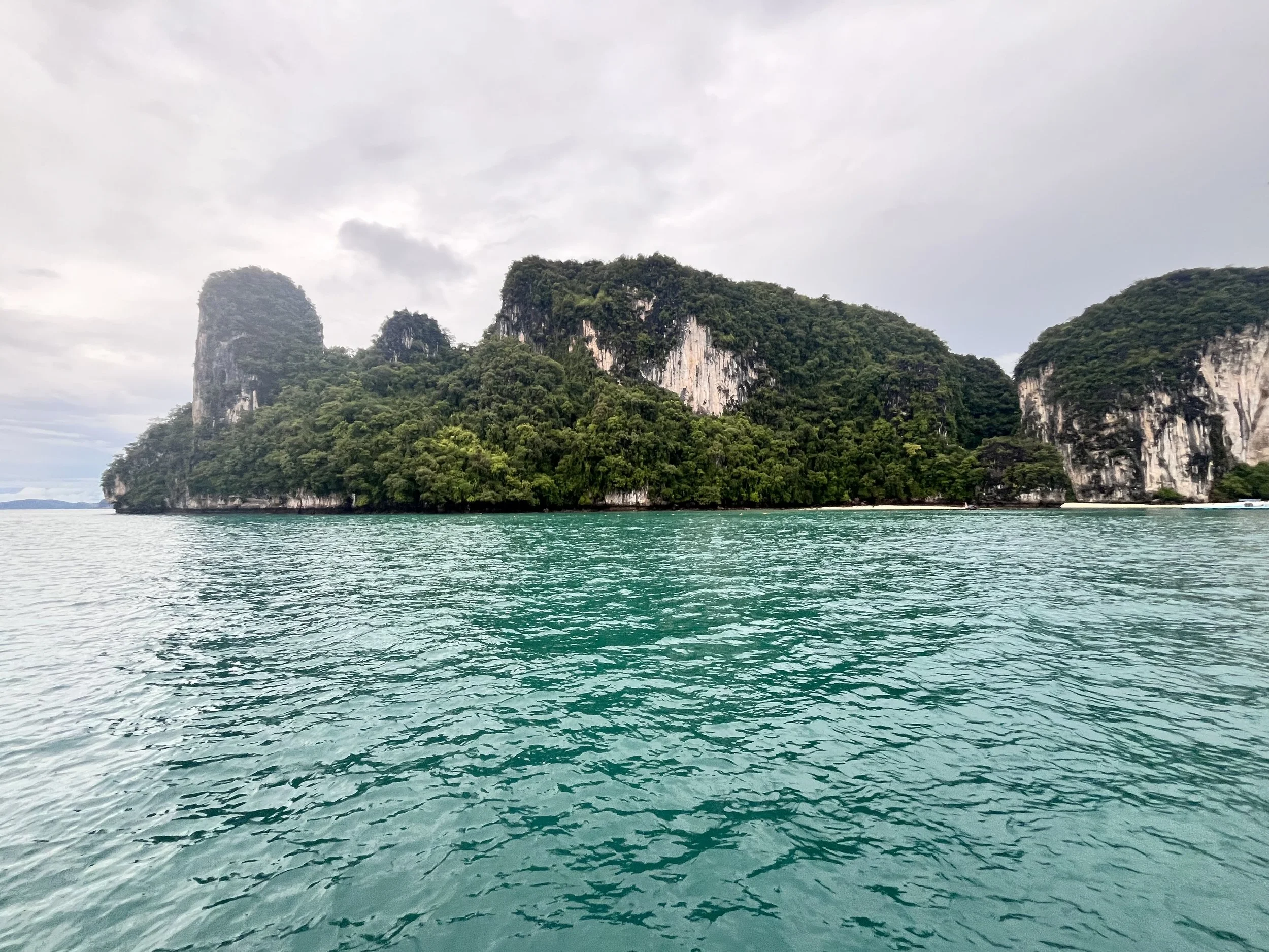
We decided to have lunch and move on to another island called Ko Hung which would offer good protection from the likely wind overnight from the North/ Northeast. We could see the rain potentially threatening from the East and so we upped anchor and headed South toward Ko Hung. The wind had dropped so there was no point in sailing. We had a couple of kts of tide with us and so we were making 8 kts and hopefully we will miss the rain which was coming in from the East. We passed a number of islands on the way and on the North side of Koh Hung is a nice anchorage with two lovely white sandy beaches and at high tide there is an entry into a large Hong. There were a number of boats already there. However, this would be exposed so we went round the East of the island to a bay with beaches on the South side. We did not realise that this island was a major tourist attraction and as we came round the corner the bay was full of longboats and tourist boats and mooring buoys most of which were occupied. There was little room.
Koh Hong, or Hong Island, is an island in Thailand's Krabi Province known for its central lagoon and limestone cliffs. It is part of the Laopilae archipelago within Thanbok Khoranee National Park and is popular for its scenic beauty, white-sand beaches, and clear waters suitable for snorkelling. Krabi is a province (changwat) of southern Thailand, on the shore of the Andaman Sea. Neighbouring provinces are (from north clockwise) Phang Nga, Surat Thani, Nakhon Si Thammarat, and Trang. Phuket province lies to the west across Phang Nga Bay. Krabi town is the seat of the provincial government.
The region of Krabi is characterized by distinctive limestone formations known as mogotes, which are scattered both inland and along the coast. These geological features attract rock climbers globally, particularly to Ton Sai Beach and Railay Beach on the Phra Nang Peninsula. Among Krabi's 154 islands, Ko Phi Phi Le stands out for its recognition as a filming location for the movie The Beach. Other significant islands include Ko Phi Phi Don, a part of the Phi Phi Islands, and Ko Lanta, a larger island situated to the south. The coastal area of Krabi suffered extensive damage during the tsunami on 26 December 2004.
Krabi's mogotes are home to numerous caves, many of which feature speleothems such as stalactites and stalagmites. Notably, the caves of Tham Chao Le and Tham Phi Hua To in the Ao Luek District house prehistoric rock paintings that depict humans, animals, and geometric shapes. In 1986, the Lang Rong Rien cave yielded 40,000-year-old human artifacts, including stone tools, pottery, and bones, marking one of the earliest known human settlements in Southeast Asia. Additionally, these caves are a primary source for the nests of the edible-nest swiftlet, which are used in the preparation of bird's nest soup.
Agriculture in Krabi is predominantly focused on rubber and palm oil production. Palm oil plantations alone cover approximately 1,568 km2 (605 sq mi), accounting for 52 percent of the province's agricultural land. Combined, palm oil and rubber plantations constitute 95 percent of Krabi's cultivated land, with a mix of smallholder farms and larger industrial plantations. The total forested area in Krabi is around 915 km2 (353 sq mi), representing 17.2 percent of the province's total area.
We motored around the bay and I watched the depth and the lowest depth I saw was about 19-20 meters but there was little space. There must have been about 30 boats here and lots of people on the beaches. There was a yellow buoy toward the far end and it was free. We went over to it and thought we would lasso it and then wait for the tourists to go. It did have a bridle but it was not the best of conditions. The buoy itself looked quite strong so I thought I would put on the anchor alarm and see if we dragged.
In the distance we saw rain coming and some of the tourist boats headed for safety. I kept the wind gauge on and the rain hit us and the wind got up to about 15 kts. Overnight it is supposed to go to 20-25 kts and so it was a good test for the buoy. We moved around a bit but held and the rain pelted down. There were many people on the beach who were in the downpour. There was a sort of plastic pier out from the beach which had a small shelter and there were so many people trying to get under it to hide from the rain. I felt a bit sorry for these people who had come for what they thought a good sunset on the beach.
The rain continued and the boats tried to collect their passengers and leave. Gradually the number of boats lessened and over the next hour or two the rain stopped. In the distance the clouds looked threatening and I was sure we would get more rain over the evening and night. We sat and read and watched the bay gradually clear as the boats went away. Mark and Keith started cooking a spaghetti bolognaise which took some time. However, once done we had a great supper in the cockpit and it was not raining yet.
We will see whether it rains in the night but tomorrow the forecast is for 37mm of rain. We shall see whether this is correct and what we are able to do.
The picture of the day is a picture of Koh Hong before the rain came in.
Need/Opportunity Year Three
In year three I will be going from Thailand to Sri Lanka, India, Maldives and then on to Chagos, Mauritius, Reunion, Cape Town, St Helena, Azores and back to the UK. I am looking for crew from Mauritius/ Reunion Island to Cape Town and from Cape Town to the UK. If of any interest do email me.
The blog will continue as we continue the journey. If you have any comments or suggestions about the blog then do email me on hine.nick9@gmail.com